IMAGES TAKEN NEAR TO
Luddendenfoot, HALIFAX, HX2 6EW
Introduction
This page details the photographs taken nearby to HX2 6EW by members of the Geograph project.
The Geograph project started in 2005 with the aim of publishing, organising and preserving representative images for every square kilometre of Great Britain, Ireland and the Isle of Man.

There are currently over 7.5m images from over14,400 individuals and you can help contribute to the project by visiting https://www.geograph.org.uk
Image Map
Images are licensed for reuse under creativecommons.org/licenses/by-sa/2.0
Notes
- Clicking on the map will re-center to the selected point.
- The higher the marker number, the further away the image location is from the centre of the postcode.
Image Listing (60 Images Found)
Images are licensed for reuse under creativecommons.org/licenses/by-sa/2.0
Image
Details
Distance
3
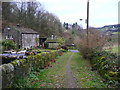
Lane below Swamp, near Finkle Street, Luddenden Foot
The reservoir is on the left, and Styes Lane comes in on the right. Warley is in the distance on the far side of the Calder valley.
Image: © Humphrey Bolton
Taken: 27 Feb 2009
0.06 miles
4
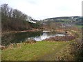
Reservoir, near Finkle Street, Luddenden Foot
This reservoir was used to supply the steam trains with water, and I think it is fed from the two small reservoirs at Higgin (SE034242).
Image: © Humphrey Bolton
Taken: 27 Feb 2009
0.06 miles
6
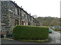
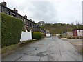
Finkle Street, Luddenden Foot
These houses are next to the site of Swamp Mill, so might have been built as homes for the mill's workforce.
Image: © Humphrey Bolton
Taken: 27 Feb 2009
0.08 miles
8
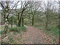
Disused field access track off Acre Lane
Image: © Humphrey Bolton
Taken: 27 May 2013
0.10 miles
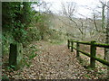
9
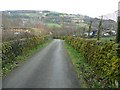
Sowerby Bridge FP67 at Styes Lane, Luddendenfoot
Old maps show the path going through the farmyard of Jack Hey, but now it goes round the farm on the north side.
Image: © Humphrey Bolton
Taken: 5 Dec 2017
0.10 miles
10
Former United Methodist Church, Clough
Image: © Alexander P Kapp
Taken: 22 Apr 2009
0.11 miles