IMAGES TAKEN NEAR TO
Tanfield Grove, HULL, HU9 4PB
Introduction
This page details the photographs taken nearby to Tanfield Grove, HU9 4PB by members of the Geograph project.
The Geograph project started in 2005 with the aim of publishing, organising and preserving representative images for every square kilometre of Great Britain, Ireland and the Isle of Man.

There are currently over 7.5m images from over14,400 individuals and you can help contribute to the project by visiting https://www.geograph.org.uk
Image Map
Images are licensed for reuse under creativecommons.org/licenses/by-sa/2.0
Notes
- Clicking on the map will re-center to the selected point.
- The higher the marker number, the further away the image location is from the centre of the postcode.
Image Listing (199 Images Found)
Images are licensed for reuse under creativecommons.org/licenses/by-sa/2.0
Image
Details
Distance
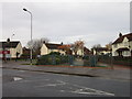


8
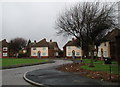
Burdale Close, Hull
Unusual triangular 'village green' style arrangement of houses between Marfleet Lane and Staveley Road in East Hull, now part of a sheltered housing scheme.
Image: © Paul Glazzard
Taken: 24 Jan 2007
0.08 miles
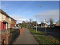
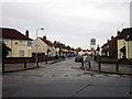
10
Staveley Road going north from Marfleet Lane
Image: © Martin Dawes
Taken: 22 Apr 2018
0.09 miles