
IMAGES TAKEN NEAR TO
Holderness Road, HULL, HU9 1EG
Introduction
This page details the photographs taken nearby to Holderness Road, HU9 1EG by members of the Geograph project.
The Geograph project started in 2005 with the aim of publishing, organising and preserving representative images for every square kilometre of Great Britain, Ireland and the Isle of Man.

There are currently over 7.5m images from over14,400 individuals and you can help contribute to the project by visiting https://www.geograph.org.uk
Image Map
Images are licensed for reuse under creativecommons.org/licenses/by-sa/2.0
Notes
- Clicking on the map will re-center to the selected point.
- The higher the marker number, the further away the image location is from the centre of the postcode.
Image Listing (448 Images Found)
Images are licensed for reuse under creativecommons.org/licenses/by-sa/2.0
Image
Details
Distance
1
Holderness Road, Kingston upon Hull
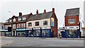
At the junction with Thomas Street, Nos.26-32 Holderness Road, built 1929 for the Hull & Sculcoates Dispensary. A superb example of Neo-Georgian architecture, featuring good doorcases with scrolled and segmental pediments. The date stone, above the central first-floor window, reads: '. A . 1929 . D .' The Dispensary was founded 1814 for the poor. It entered into voluntary liquidation 1958 when the Holderness Road branch was sold, the proceeds to the Hull & Sculcoates Dispensary Aid Trust. Now occupied by Academy Upholstery. Adjoining, at Nos.16-24, four former houses, late 19th century, now occupied by PMW Scooters & Bikes. The gap between Nos. 16 and 20 is the entrance to the former Blockhouse Mill yard.
Image: © Bernard Sharp
Taken: 30 May 2013
0.01 miles
2

Holderness Road, Kingston upon Hull
At the junction with Thomas Street, Nos.26-32 Holderness Road, built 1929 for the Hull & Sculcoates Dispensary. A superb example of Neo-Georgian architecture, featuring good doorcases with scrolled and segmental pediments. The date stone, above the central first-floor window, reads: '. A . 1929 . D .' The Dispensary was founded 1814 for the poor. It entered into voluntary liquidation 1958 when the Holderness Road branch was sold, the proceeds to the Hull & Sculcoates Dispensary Aid Trust. Now occupied by Academy Upholstery.
Image: © Bernard Sharp
Taken: 30 May 2013
0.02 miles

4

Holderness Road, Kingston upon Hull
Together with Nos.2, 4 & 6 Dansom Lane, No.1 Holderness Road, was built circa 1850, distinctive for the way they curve satisfyingly round the corner. Several of the windows to the first floor are round-headed.
Image: © Bernard Sharp
Taken: 30 May 2013
0.02 miles
5
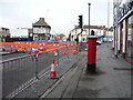
Roadworks on Clarence Street, Hull
Showing position of Postbox No. HU9 80.
See Image] for postbox.
Image: © JThomas
Taken: 7 Dec 2019
0.02 miles
6

George V postbox on Clarence Street, Hull
Image: © JThomas
Taken: 7 Dec 2019
0.02 miles
8

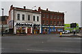
Holderness Road, Kingston upon Hull
The junction of Witham, Dansom Lane, Holderness Road, Blyth Street, Naylor's Row and Clarence Street, much as it would have looked in 1902 when the last-mentioned street was constructed.
Left to right: Holderness Inn, No.55 Witham; Nos.2-6 Dansom Lane & No.1 Holderness Road; Nos.2 to 10 Holderness Road.
Image: © Bernard Sharp
Taken: 8 Jun 2013
0.02 miles
9

Dansom Lane, Kingston upon Hull
Together with No.1 Holderness Road, Nos.2, 4 & 6 Dansom Lane were built circa 1850, distinctive for the way they curve satisfyingly round the corner. Several of the windows to the first floor are round-headed.
No.2 Dansom Lane is presently occupied by the Corner House Café.
Originally Clow Lane, then Mill Lane, later Cowhouse Mill Lane, the street takes its present name from Robert Dansom who had a farm situated near the site of the playground.
Image: © Bernard Sharp
Taken: 30 May 2013
0.02 miles
10

The Holderness public house on Damson Lane South
Image: © Ian S
Taken: 21 Jul 2012
0.02 miles