IMAGES TAKEN NEAR TO
Egginton Street, HULL, HU2 8DL
Introduction
This page details the photographs taken nearby to Egginton Street, HU2 8DL by members of the Geograph project.
The Geograph project started in 2005 with the aim of publishing, organising and preserving representative images for every square kilometre of Great Britain, Ireland and the Isle of Man.

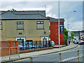
There are currently over 7.5m images from over14,400 individuals and you can help contribute to the project by visiting https://www.geograph.org.uk
Image Map
Images are licensed for reuse under creativecommons.org/licenses/by-sa/2.0
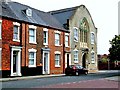
Notes
- Clicking on the map will re-center to the selected point.
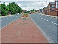
- The higher the marker number, the further away the image location is from the centre of the postcode.
Image Listing (1365 Images Found)
Images are licensed for reuse under creativecommons.org/licenses/by-sa/2.0
Image
Details
Distance
1
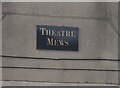
Theatre Mews off Egginton Street, Hull
https://www.geograph.org.uk/photo/6771291
Image: © Ian S
Taken: 25 Feb 2021
0.01 miles
2
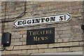
Egginton Street, Hull
https://www.geograph.org.uk/photo/6771398
Image: © Ian S
Taken: 25 Feb 2021
0.01 miles
3
Theatre Mews off Egginton Street, Hull
https://www.geograph.org.uk/photo/6771293
Image: © Ian S
Taken: 25 Feb 2021
0.01 miles
4
John Street, Kingston upon Hull
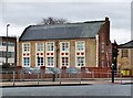
At the eastern end of the street stands the former Christ Church School, 1847 by Cuthbert Brodrick. The east facing side seen from Freetown Way illustrates the cream brick with stone details. The building was converted to flats in 1994.
Image: © Bernard Sharp
Taken: 3 Jan 2013
0.01 miles
5
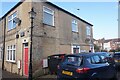
Theatre Mews and Freetown Way
This new development looks onto the dual carriageway, Freetown Way, so named because Freetown Sierra Leone is Hull's twin city. Hull was the first city to twin with a city in a "Third World" country, and it is appropriate that Fairtrade City lamppost banners should be seen on this road.
Image: © Peter Church
Taken: 12 Jul 2008
0.01 miles
6

John Street, Kingston upon Hull
At the eastern end of the street stands the former Christ Church School, 1847 by Cuthbert Brodrick. Cream brick with stone details. Perpendicular doorway with large Decorated window above. The building was converted to flats in 1994, becoming Raywell House, No.30 John Street.
Image: © Bernard Sharp
Taken: 26 Feb 2014
0.01 miles
7
John Street, Kingston upon Hull
At the eastern end of the street stands the former Christ Church School, 1847 by Cuthbert Brodrick. The building was converted to flats in 1994.
Image: © Bernard Sharp
Taken: 1 Jan 2005
0.02 miles
8

John Street, Kingston upon Hull
Houses at Nos.23-29; the former Christ Church School at No.30, the latter converted to flats in 1994.
Image
Image: © Bernard Sharp
Taken: 26 Feb 2013
0.02 miles
9

John Street, Kingston upon Hull
The rear of the north side of the street seen from Eggington Street.
The former Christ Church School is easternmost of the terrace.
Image: © Bernard Sharp
Taken: Unknown
0.02 miles
10
Freetown Way, Hull
A major dual carriageway, but a 30 mph speed limit as well.
Image: © Peter Church
Taken: 12 Jul 2008
0.02 miles