IMAGES TAKEN NEAR TO
Elm Croft, BEVERLEY, HU17 8RS
Introduction
This page details the photographs taken nearby to Elm Croft, HU17 8RS by members of the Geograph project.
The Geograph project started in 2005 with the aim of publishing, organising and preserving representative images for every square kilometre of Great Britain, Ireland and the Isle of Man.

There are currently over 7.5m images from over14,400 individuals and you can help contribute to the project by visiting https://www.geograph.org.uk
Image Map
Images are licensed for reuse under creativecommons.org/licenses/by-sa/2.0
Notes
- Clicking on the map will re-center to the selected point.
- The higher the marker number, the further away the image location is from the centre of the postcode.
Image Listing (20 Images Found)
Images are licensed for reuse under creativecommons.org/licenses/by-sa/2.0
Image
Details
Distance
1

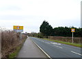
Approaching the junction of Coppleflat Lane and the B1230
Image: © Chris
Taken: 17 May 2014
0.05 miles

3
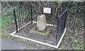
Old Wayside Cross
Walkington Cross, a wayside cross with an old shaft & base. Set in a hedge with railings around on the south side of the B1230 Beverley Road on the eastern side of the village in Walkington parish. King Athelstan visited Beverley in the 10th century to solicit support from St John of Beverley (who died in 721) in his campaign to subdue northern Britain. Following his success, he granted the town enhanced sanctuary boundaries, marking four main roads with crosses around a mile and a half from the Minster where legend tells us he provided a Frith Stool (means peace and protection in Old English) for miscreants to claim sanctuary. A Scheduled Monument https://historicengland.org.uk/listing/the-list/list-entry/1012591.
Milestone Society National ID: YEER_BEV03
Image: © D Garside
Taken: 8 Jan 2019
0.07 miles
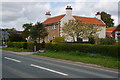
4

Walkington Sanctuary Stone
Beside the B1230. Originally an ornate carved stone cross. It was one of four stones to be found on the four approach roads into Beverley, each one 2 miles from Beverley Minster.
Image: © JThomas
Taken: 28 Dec 2019
0.08 miles
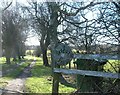
7
Coppleflat Lane, Walkington
This is the approach from the south.
Image: © Peter Church
Taken: 6 Feb 2008
0.10 miles
8

Tour de Yorkshire bunting on Broadgate, Walkington
Image: © Ian S
Taken: 2 May 2015
0.12 miles
9

Ploughed field and pylons
Off Coppleflat Lane.
Image: © JThomas
Taken: 28 Dec 2019
0.14 miles