IMAGES TAKEN NEAR TO
Abbey Lane, HULL, HU10 6FX
Introduction
This page details the photographs taken nearby to Abbey Lane, HU10 6FX by members of the Geograph project.
The Geograph project started in 2005 with the aim of publishing, organising and preserving representative images for every square kilometre of Great Britain, Ireland and the Isle of Man.

There are currently over 7.5m images from over14,400 individuals and you can help contribute to the project by visiting https://www.geograph.org.uk
Image Map
Images are licensed for reuse under creativecommons.org/licenses/by-sa/2.0
Notes
- Clicking on the map will re-center to the selected point.
- The higher the marker number, the further away the image location is from the centre of the postcode.
Image Listing (18 Images Found)
Images are licensed for reuse under creativecommons.org/licenses/by-sa/2.0
Image
Details
Distance
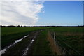
2
A walk from Hessle Square #28
Haltemprice Farm.
Image: © Ian S
Taken: 11 Aug 2010
0.00 miles
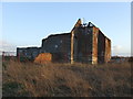
3
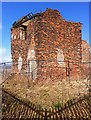
Haltemprice Farm
The long-derelict farmhouse, or what remains of it, seen from behind the security fencing which now surrounds it (and which throws the shadow seen here).
Image: © Paul Harrop
Taken: 24 Feb 2015
0.01 miles
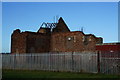
4
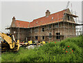
New Haltemprice Farm?
New house under construction on the site of the former Haltemprice Priory/Farmhouse which was in a ruinous state for many years (as shown here: Image Image).
Image: © Paul Harrop
Taken: 10 Jul 2021
0.01 miles
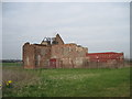
5
Haltemprice Priory Farm
This historic site, is sadly ruined.
See http://en.wikipedia.org/wiki/Haltemprice_Priory for further information.
Image: © Peter Church
Taken: 3 Feb 2008
0.01 miles
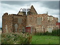
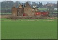
6
Haltemprice Priory Farm
The remains of the farmhouse, originally built in the 16th to 17th century on the site of the former Augustinian priory. Information on the priory and the farm can be found here: http://www.yorkshirehistory.com/haltemprice.htm
Image: © Paul Glazzard
Taken: 31 May 2007
0.02 miles
7

Haltemprice Priory Farm at Sunset
The site of Haltemprice Priory Farm at sunset. Photo taken from the rear of properties at Chester Road.
The original monastic buildings of Haltemprice Priory (1320 >) have long since gone, although ruins of a farmhouse, built 1584 remain on site and incorporate some of the Priory stonework.
This photo shows the ruins of the 16th Century farmhouse which has fallen into decline over the past 20 years or so. In the distance (mid right) construction can be seen taking place at Castle Hill Hospital.
For more on Haltemprice Priory see:
http://en.wikipedia.org/wiki/Haltemprice_Priory
Image: © Chris Rowson
Taken: 1 Jun 2007
0.03 miles
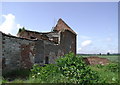
9
A Derelict Farm with History
A priory for Augustinian canons was founded at Cottingham in 1320 and transferred to this site in 1326. Nothing survives, although the farmhouse incorporates material from the priory. The farm has been derelict for at least 20 years to my knowledge.
Image: © Martin Dawes
Taken: 21 Mar 2012
0.05 miles