IMAGES TAKEN NEAR TO
Lower Bayble, ISLE OF LEWIS, HS2 0QA
Introduction
This page details the photographs taken nearby to HS2 0QA by members of the Geograph project.
The Geograph project started in 2005 with the aim of publishing, organising and preserving representative images for every square kilometre of Great Britain, Ireland and the Isle of Man.

There are currently over 7.5m images from over14,400 individuals and you can help contribute to the project by visiting https://www.geograph.org.uk
Image Map
Images are licensed for reuse under creativecommons.org/licenses/by-sa/2.0
Notes
- Clicking on the map will re-center to the selected point.
- The higher the marker number, the further away the image location is from the centre of the postcode.
Image Listing (6 Images Found)
Images are licensed for reuse under creativecommons.org/licenses/by-sa/2.0
Image
Details
Distance
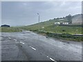
2
Looking In
Looking from the road to the pier and back in to the crossroads which gives Lower Bayble to the left and Upper Bayble to the right.
Image: © Stephen Branley
Taken: 3 Dec 2008
0.20 miles
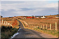
3

Upper Bayble
A view from Upper Bayble to the junction at the bottom of the hill. The road to the pier is out of shot to the left behind the first white house.
Image: © Stephen Branley
Taken: 3 Dec 2008
0.20 miles
4
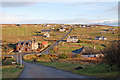
Lower Bayble
Looking down the very steep hill (not good in winter!) to the junction and the road that leads to Upper Bayble (Gaelic - Pabail Uarach) in the distance.
Image: © Stephen Branley
Taken: 3 Dec 2008
0.20 miles
5
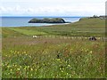
Crofts at Pabail Iarach
From the village, the crofts slope down to Bagh Pabail (Bayble Bay). As the OS 1:25,000 map illustrates, the croft boundaries form a fan shape as they descend to the sea.
Image: © Eileen Henderson
Taken: 29 Jun 2007
0.21 miles
6
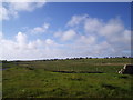
Looking north towards Pabail
The crofts and houses of Pabail Iarach and Pabail Uarach are spread out over the land in Lewis's Eye peninsula
Image: © John Aldersey-Williams
Taken: 13 Jun 2005
0.24 miles