IMAGES TAKEN NEAR TO
New Tolsta, ISLE OF LEWIS, HS2 0NN
Introduction
This page details the photographs taken nearby to HS2 0NN by members of the Geograph project.
The Geograph project started in 2005 with the aim of publishing, organising and preserving representative images for every square kilometre of Great Britain, Ireland and the Isle of Man.

There are currently over 7.5m images from over14,400 individuals and you can help contribute to the project by visiting https://www.geograph.org.uk
Image Map
Images are licensed for reuse under creativecommons.org/licenses/by-sa/2.0
Notes
- Clicking on the map will re-center to the selected point.
- The higher the marker number, the further away the image location is from the centre of the postcode.
Image Listing (6 Images Found)
Images are licensed for reuse under creativecommons.org/licenses/by-sa/2.0
Image
Details
Distance
1
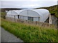
Polytunnel View
A busy looking twin polytunnel unit as view in late September.
Image: © Rude Health
Taken: 22 Sep 2013
0.05 miles
2
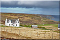
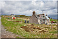
Traditional House at Tolastadh
This is the same house as Image] in rather different light, and showing the coast further north.
Image: © Anne Burgess
Taken: 14 May 2011
0.13 miles
3
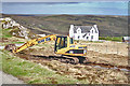
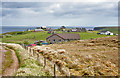
Excavation at Tolastadh
I understand that the digger is preparing a site for a wind turbine. There are to be two, one at each end of the village, to supply power to the residents.
Image: © Anne Burgess
Taken: 14 May 2011
0.14 miles
4
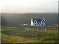
Croft House, New Tolsta
This house is a stunning example of a Lewis croft house. The pointed 'Storm' windows on the upper floor are very practical with the extreme weather often experienced in the islands. Whitewashed walls are also fairly common in the islands. In the background is the moorland between Tolsta and Ness where there is a wonderful coastal trail starting at Garry Bridge Image which I would recommend to every visitor to the area.
Image: © Donald Lawson
Taken: 30 Jun 2006
0.17 miles
5
Bail' Ur Tholastaidh (New Tolsta)
Bail' Ur Tholastaidh is the last crofting community on the way north to Tràigh Ghearadha.
Image: © Anne Burgess
Taken: 14 May 2011
0.18 miles
6
Tolastadh (Tolsta)
The track here meets the B895 between Bail' Ur Tholastaidh (new Tolsta) to the north and Tolastadh bho Tuath (North Tolsta) to the south. The houses in the background are on Cnoc-Glas, and the distant cliff is part of Rubha Tholastaidh (Tolsta Head).
Image: © Anne Burgess
Taken: 14 May 2011
0.24 miles