IMAGES TAKEN NEAR TO
Old Market Close, ROSS-ON-WYE, HR9 7QB
Introduction
This page details the photographs taken nearby to Old Market Close, HR9 7QB by members of the Geograph project.
The Geograph project started in 2005 with the aim of publishing, organising and preserving representative images for every square kilometre of Great Britain, Ireland and the Isle of Man.

There are currently over 7.5m images from over14,400 individuals and you can help contribute to the project by visiting https://www.geograph.org.uk
Image Map (Loading...)


Getting Data...Please wait
Leaflet Map data © OpenStreetMap
Images are licensed for reuse under creativecommons.org/licenses/by-sa/2.0
Notes
- Clicking on the map will re-center to the selected point.
- The higher the marker number, the further away the image location is from the centre of the postcode.
Image Listing (396 Images Found)
Images are licensed for reuse under creativecommons.org/licenses/by-sa/2.0
Image
Details
Distance
1
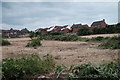
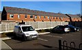
Former allotments
Planning permission for the development of a housing estate on this field has been in place for a few years now, and the site has recently been cleared. When I moved to Ross 11 years ago, this was all allotments: "I remember when this didn't used to be all fields", you might say. In the background are houses on River View.
Image: © John Winder
Taken: 9 Jun 2020
0.03 miles
2
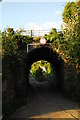
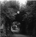
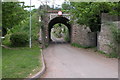
Cawdor Arch, Ross on Wye
The old railway bridge in Ross, one of an ever decreasing number of physical reminders of the railway presence. This was constructed to broad gauge dimensions which is why it appears more like a short tunnel than a bridge. There's talk that this will be demolished soon in order to allow construction lorries access to the allotments beyond, which have been earmarked for housing development.
Image: © John Winder
Taken: 19 Apr 2014
0.03 miles
3
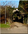
Former railway bridge, Cawdor Arch Road, Ross-on-Wye
A railway used to cross this bridge. Headroom shown is 11' 0".
Image: © Jaggery
Taken: 8 Feb 2015
0.03 miles
4
Cawdor Arch
The arch of the old railway bridge, which was built to carry the broad gauge line to Hereford in 1855, is barely visible beneath the undergrowth. The bridge is soon to be demolished in order to allow access for large vehicles in connection with a proposed residential development on a field nearby. Even a committed railway archaeologist like me can see that it's difficult to argue a case for retaining the bridge - it hasn't carried a train since the line north of Ross was closed in October 1964 - but it's a shame to see Ross's railway heritage gradually disappearing.
Image: © John Winder
Taken: 9 Jun 2020
0.03 miles
5
Cawdor Arch, Ross on Wye
I've photographed this before, but I like this particular shot. Taken with my elderly Agfa Isolette. The bridge used to carry the railway to Hereford, which closed in 1964. Sadly, it's under threat of demolition as there's a plan to build houses on the allotments on the other side of the arch, and the bridge would have to go to allow access for construction traffic.
Image: © John Winder
Taken: Unknown
0.03 miles
6
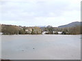
Ross-under-Wye II
The latest floods by the river in a view eastwards from the bypass, with the dome of May Hill looming in the distance.
Image: © Jonathan Billinger
Taken: 11 Jan 2007
0.03 miles
7
Zigzag roof pattern, Old Market Close, Ross-on-Wye
Is the red zigzag on modern housing purely decorative?
Image: © Jaggery
Taken: 8 Feb 2015
0.04 miles
8
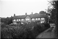
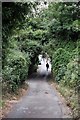
Houses and abandoned allotments
The overgrown area in the left foreground was formerly used as allotments, now abandoned and earmarked for a housing development. Shot on film using a Braun Paxette.
Image: © John Winder
Taken: Unknown
0.04 miles
9
Redundant Railway Bridge at Ross-on-Wye
This railway bridge used to carry the Ross to Hereford railway which closed in the mid 1960s. As can be seen, the embankment to the left has gone and the former railway's course has now been built on.
Image: © Philip Halling
Taken: 7 May 2006
0.05 miles
10
Hedgehog's revenge
The hedgehog has been associated with Ross on Wye since around 500AD, when the Celts invaded Ross and called the area "Ergyng", meaning "Land of the Hedgehogs". The old name survives in a mutated form as "Archenfield", an area on the south edge of modern-day Ross. There are at least fourteen representations of hedgehogs in the town's church, as well as some less official ones on roadsigns.
Image: © John Winder
Taken: 9 Jun 2020
0.05 miles