IMAGES TAKEN NEAR TO
Bury Hill, ROSS-ON-WYE, HR9 7PS
Introduction
This page details the photographs taken nearby to Bury Hill, HR9 7PS by members of the Geograph project.
The Geograph project started in 2005 with the aim of publishing, organising and preserving representative images for every square kilometre of Great Britain, Ireland and the Isle of Man.

There are currently over 7.5m images from over14,400 individuals and you can help contribute to the project by visiting https://www.geograph.org.uk
Image Map
Images are licensed for reuse under creativecommons.org/licenses/by-sa/2.0
Notes
- Clicking on the map will re-center to the selected point.
- The higher the marker number, the further away the image location is from the centre of the postcode.
Image Listing (62 Images Found)
Images are licensed for reuse under creativecommons.org/licenses/by-sa/2.0
Image
Details
Distance
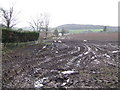
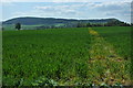
1
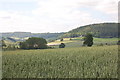
Croplines to Bury Hill
View south-east across the gridline from the same spot as Image and Image
May Hill can be seen in the left distance.
Image: © Jonathan Billinger
Taken: 22 May 2010
0.04 miles
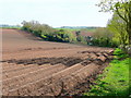
3
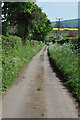
Lane at Bury Hill
Narrow country lane at Bury Hill.
Image: © Philip Halling
Taken: 25 Apr 2011
0.05 miles
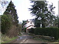
4

Pond Cottage, Bury Hill
Because it is pink...
Image: © Bob Embleton
Taken: 19 Feb 2006
0.05 miles
5
View to the Penyard
The field in the foreground leads down to recently created fishing lakes, whilst in the distance is the flat-topped hill known as the Penyard.
Image: © Jonathan Billinger
Taken: 18 Jan 2007
0.06 miles
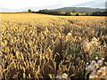
6
Cereal field near Bollitree Castle in early June
Image: © Roger Davies
Taken: 2 Jun 2011
0.07 miles
7
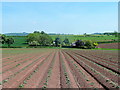
Freshly planted potato field
East of Bury Lane, Between Weston and Bromsash.
Image: © Jonathan Billinger
Taken: 9 Apr 2011
0.08 miles
8
View over Bury Hill
Towards East Dean - the northern edge of the Forest of Dean.
Image: © Pauline E
Taken: 2 Aug 2008
0.08 miles
9
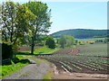
Track to irrigation ponds
The watering is essential for a thirsty crop like potatoes.
View south-west from Bury Hill with Penyard Hill in the distance.
Image: © Jonathan Billinger
Taken: 22 May 2010
0.09 miles
10
Footpath through a cereal field, Bury Hill
The route of the footpath has been sprayed by the farmer. The wooded hill in the background in Penyard Park.
Image: © Philip Halling
Taken: 25 Apr 2011
0.10 miles