IMAGES TAKEN NEAR TO
Foy, ROSS-ON-WYE, HR9 6RD
Introduction
This page details the photographs taken nearby to HR9 6RD by members of the Geograph project.
The Geograph project started in 2005 with the aim of publishing, organising and preserving representative images for every square kilometre of Great Britain, Ireland and the Isle of Man.

There are currently over 7.5m images from over14,400 individuals and you can help contribute to the project by visiting https://www.geograph.org.uk
Image Map
Images are licensed for reuse under creativecommons.org/licenses/by-sa/2.0
Notes
- Clicking on the map will re-center to the selected point.
- The higher the marker number, the further away the image location is from the centre of the postcode.
Image Listing (5 Images Found)
Images are licensed for reuse under creativecommons.org/licenses/by-sa/2.0
Image
Details
Distance
1
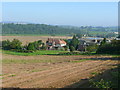
Underhill Farm
A mixed farming enterprise on land bordering the Wye.
Image: © Jonathan Billinger
Taken: 26 Sep 2008
0.09 miles
2
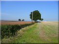
Field boundary near Foy
One field is sown for 2009 season, and the stubble field awaits similar treatment.
Image: © Jonathan Billinger
Taken: 26 Sep 2008
0.17 miles
3
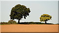
Two oak trees and a buzzard
Taken with the use of telephoto from the lane to Foy.
Image: © Jonathan Billinger
Taken: 30 Aug 2018
0.21 miles
4
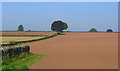
Farmland at Foy
A recently drilled crop in the fine red soil of the Wye valley in Herefordshire.
Looking north-west towards the crest of the long ridge which forces the Wye into one of its many convoluted bends between Hereford and Ross-on-Wye.
Image: © Jonathan Billinger
Taken: 26 Sep 2008
0.22 miles
5
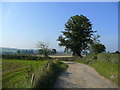
Track to Hillcrest and Underhill
A kink in the track from Foy.
Image: © Jonathan Billinger
Taken: 26 Sep 2008
0.24 miles