IMAGES TAKEN NEAR TO
Llangarron, ROSS-ON-WYE, HR9 6NT
Introduction
This page details the photographs taken nearby to HR9 6NT by members of the Geograph project.
The Geograph project started in 2005 with the aim of publishing, organising and preserving representative images for every square kilometre of Great Britain, Ireland and the Isle of Man.

There are currently over 7.5m images from over14,400 individuals and you can help contribute to the project by visiting https://www.geograph.org.uk
Image Map
Images are licensed for reuse under creativecommons.org/licenses/by-sa/2.0
Notes
- Clicking on the map will re-center to the selected point.
- The higher the marker number, the further away the image location is from the centre of the postcode.
Image Listing (11 Images Found)
Images are licensed for reuse under creativecommons.org/licenses/by-sa/2.0
Image
Details
Distance
1
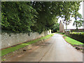
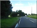
Country road in Biddlestone
Approaching a junction with the A4137. Taken in a brief interlude of sunshine on a day of heavy downpours.
Image: © Pauline E
Taken: 4 Sep 2008
0.02 miles
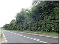
3
'CAUTION CHILDREN AND STOCK CROSSING'
Warning sign on the approach to Biddlestone.
Image: © Philip Halling
Taken: 28 Jan 2006
0.05 miles
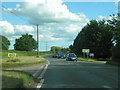
5
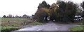
Staggered crossroads with a turn for Biddlestone
Image: © David Smith
Taken: 29 Sep 2016
0.07 miles
6
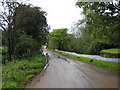
Road to Tretire
From Biddlestone. Approaching a fork in this narrow road which has no signs.
Image: © Pauline E
Taken: 4 Sep 2008
0.09 miles
9
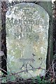
Old Milestone by the A4137, near Biddlestone
Carved stone post by the A4137, in parish of Llangarron (District), South of Biddlestone, by hedge, on West side of road. Whitchurch Monmouth Roman stone, erected by the Whitchurch & Llangarren turnpike trust in the 19th century.
N.B. Listing Grid Reference doesn't match the O.S. or actual location.
Inscription reads:-
To
Monmouth
VIII
Miles
Carved benchmark front mid lower.
Grade II listed.
List Entry Number: 1178559 https://historicengland.org.uk/listing/the-list/list-entry/1178559
Milestone Society National ID: HF_HFMNA12
Image: © TE Keegan
Taken: 3 Jan 2005
0.13 miles
10
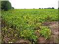
Potato field west of Biddlestone
The crop will shortly be harvested. It is likely that the haulm (green parts) will be chemically desiccated in order that the crop can be lifted easily with less chance of fungal diseases in store.
This land used to be orchards.
Image: © Jonathan Billinger
Taken: 25 Sep 2008
0.16 miles