IMAGES TAKEN NEAR TO
Bishopswood, ROSS-ON-WYE, HR9 5QX
Introduction
This page details the photographs taken nearby to HR9 5QX by members of the Geograph project.
The Geograph project started in 2005 with the aim of publishing, organising and preserving representative images for every square kilometre of Great Britain, Ireland and the Isle of Man.

There are currently over 7.5m images from over14,400 individuals and you can help contribute to the project by visiting https://www.geograph.org.uk
Image Map
Images are licensed for reuse under creativecommons.org/licenses/by-sa/2.0
Notes
- Clicking on the map will re-center to the selected point.
- The higher the marker number, the further away the image location is from the centre of the postcode.
Image Listing (25 Images Found)
Images are licensed for reuse under creativecommons.org/licenses/by-sa/2.0
Image
Details
Distance
1
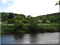
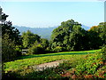
Across the River Wye
Looking to Bishop's Wood from the Wye Valley Walk.
Image: © David Purchase
Taken: 28 May 2015
0.06 miles
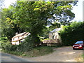
2
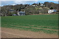
Houses in the Wye Valley
Houses in the Wye Valley near Bishop's Wood. Viewed from the banks of the River Wye.
Image: © Philip Halling
Taken: 30 Mar 2008
0.07 miles
3
In Drybrook, between the woods and the Wye
Image: © David Smith
Taken: 24 Jul 2013
0.09 miles
4
The Wye valley
Between Kerne Bridge and Lower Lydbrook.
Image: © Jonathan Thacker
Taken: 17 Sep 2020
0.14 miles
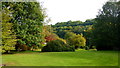
5
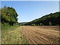
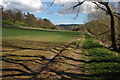
The wooded Wye valley
Oaks and pasture at Bishopswood.
Image: © Jonathan Billinger
Taken: 26 Sep 2008
0.15 miles
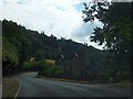
6
Houses near Kerne Bridge
Look across the River Wye.
Image: © Jonathan Thacker
Taken: 17 Sep 2020
0.17 miles
7
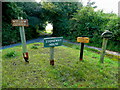
Signs by a private road
Four properties on the sunny side of the Wye valley at Bishopswood.
Image: © Jonathan Billinger
Taken: 26 Sep 2008
0.18 miles
8
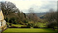
Hazelhurst grounds
Hazelhurst is a Nursing and Care Home set in stunning grounds within the landscape of the Wye Valley AONB.
Image: © Jonathan Billinger
Taken: 23 Sep 2017
0.18 miles
9
Hazelhurst grounds in March
The Wye valley trench can be seen as well as the high ground to the south of Ruardean.
Image: © Jonathan Billinger
Taken: 11 Mar 2018
0.19 miles
10
River bank footpath, Kerne Bridge
Footpath down the east bank of the River Wye downstream from Kerne Bridge. The B4234, which is to the left of this field, follows the course of river here as it negotiates a large bend. The spire of Ruardean church can be seen on the horizon in the background.
Image: © Philip Halling
Taken: 30 Mar 2008
0.19 miles