IMAGES TAKEN NEAR TO
Gloucester Road, ROSS-ON-WYE, HR9 5NY
Introduction
This page details the photographs taken nearby to Gloucester Road, HR9 5NY by members of the Geograph project.
The Geograph project started in 2005 with the aim of publishing, organising and preserving representative images for every square kilometre of Great Britain, Ireland and the Isle of Man.

There are currently over 7.5m images from over14,400 individuals and you can help contribute to the project by visiting https://www.geograph.org.uk
Image Map
Images are licensed for reuse under creativecommons.org/licenses/by-sa/2.0
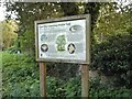
Notes
- Clicking on the map will re-center to the selected point.
- The higher the marker number, the further away the image location is from the centre of the postcode.
Image Listing (288 Images Found)
Images are licensed for reuse under creativecommons.org/licenses/by-sa/2.0
Image
Details
Distance
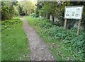
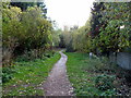
2
Trackbed, Ross and Monmouth Railway
This was once a very scenic railway down the Wye to Monmouth. It finally closed in 1965 with passenger services stopping in 1959.
Image: © Richard Webb
Taken: 14 Apr 2016
0.02 miles
3
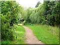
Town and country trail, Ross-on-Wye
Summer view from the same spot as Image
Image: © Jonathan Billinger
Taken: 11 Jul 2009
0.02 miles
4
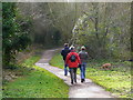
Walking on the Town and Country Trail
Looking north at the Hidersley end, Ross-on-Wye.
Image: © Jonathan Billinger
Taken: 24 Jan 2009
0.02 miles
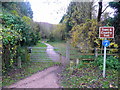
5
Town & Country Trail, Ross-on-Wye
This part of the footpath and cycleway heads south from the A40 towards Walford.
Image: © Jaggery
Taken: 30 Oct 2011
0.03 miles
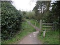
6
Ross-on-Wye town and country trail
The path follows the trackbed of the Wye Valley railway line around the south side of the town.
Image: © Jonathan Billinger
Taken: 16 Nov 2008
0.03 miles
8
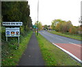
SE border of Ross-on-Wye
Viewed along Gloucester Road (the A40) from Hildersley, near the fire station. http://www.geograph.org.uk/photo/2671538 The sign shows that Ross-on-Wye is twinned with Condé-sur-Noireau (France), Namutumba (Uganda) and Betzdorf, Germany. A change since 2008 http://www.geograph.org.uk/photo/1047465 is the replacement of Ross-on-Wye with Namutumba.
Image: © Jaggery
Taken: 30 Oct 2011
0.03 miles
9
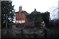
Seemingly derelict house at Ross on Wye
This is near the rifle range just outside Ross. It appears derelict from this angle but the keen eyed among you will have spotted that there's a light on ... someone does live here as far as I know! They could do with giving the ivy a trim.
Image: © John Winder
Taken: 3 Mar 2014
0.03 miles
10
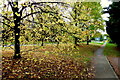
Leaves and footpath
Just caught the lime and ash leaves before they all get blown away by the first autumn gales for 2014.
The footpath follows the original alignment of Gloucester Road at Hildersley before Ross-on-Wye's eastern bypass was built.
Image: © Jonathan Billinger
Taken: 24 Oct 2014
0.04 miles