IMAGES TAKEN NEAR TO
Bramley Close, LEDBURY, HR8 2XS
Introduction
This page details the photographs taken nearby to Bramley Close, HR8 2XS by members of the Geograph project.
The Geograph project started in 2005 with the aim of publishing, organising and preserving representative images for every square kilometre of Great Britain, Ireland and the Isle of Man.

There are currently over 7.5m images from over14,400 individuals and you can help contribute to the project by visiting https://www.geograph.org.uk
Image Map
Images are licensed for reuse under creativecommons.org/licenses/by-sa/2.0
Notes
- Clicking on the map will re-center to the selected point.
- The higher the marker number, the further away the image location is from the centre of the postcode.
Image Listing (10 Images Found)
Images are licensed for reuse under creativecommons.org/licenses/by-sa/2.0
Image
Details
Distance
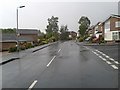
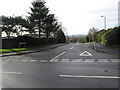
2
Estate housing in Ledbury
This is Biddulph Way, in the estate known as Deer Park, to the south of the town.
Image: © Jonathan Billinger
Taken: 31 Dec 2007
0.18 miles
3
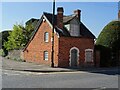
Toll Cottage
Toll Cottage on The Southend in Ledbury. This Grade II https://historicengland.org.uk/listing/the-list/list-entry/1082809 red-brick cottage probably dates from 1840.
Image: © Philip Halling
Taken: 2 Apr 2021
0.22 miles
4
Old Toll House by The Southend, Ledbury
Toll House in the parish of Ledbury (Herefordshire District), Toll Cottage, at the junction of The Southend (A449) and Mabel's Furlong.
Grade II listed.
List Entry Number: 1082809 https://historicengland.org.uk/listing/the-list/list-entry/1082809
Surveyed
Milestone Society National ID: HF.LED01
Image: © Alan Rosevear
Taken: 23 May 2006
0.22 miles
5
Toll Cottage and Gloucester House
Toll Cottage of The Southend in Ledbury, the Georgian house beyond is Gloucester House, an 18th century and like the toll cottage is Grade II listed. See: https://historicengland.org.uk/listing/the-list/list-entry/1082808
Image: © Philip Halling
Taken: 2 Apr 2021
0.23 miles
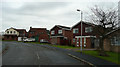
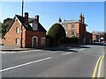
6
Junction of Biddulph Way and The Southend
Biddulph Way leads into a modern housing development. The Southend, in contrast, contains many old and interesting buildings.
Image: © Pauline E
Taken: 12 Jan 2008
0.23 miles
7
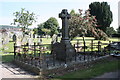
The Biddulph family vault, Ledbury cemetery
Inscribed: "This vault was built by Michael Biddulph (Dsa?) in the year 1861 as a burial place for his family; the family vault in the church of this parish having been closed by the council."
Michael Biddulph, was a partner in the London banking firm of Cocks, Biddulph and Co.
In 1865 he was elected to the House of Commons for Herefordshire, a seat he held until 1885, and then represented Ross between 1886 to 1900.
In 1903 he was raised to the peerage as Baron Biddulph, of Ledbury in the County of Hereford.
Image: © Bob Embleton
Taken: 2 Sep 2010
0.24 miles
8
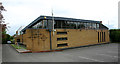
Ledbury Roman Catholic church, New Street
This church was dedicated in 1976 having replaced another church elsewhere in the town.
Image: © David Kemp
Taken: 26 May 2019
0.24 miles
9
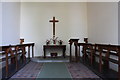
Interior of the chapel of rest, Ledbury cemetery
Rather stark, but quite light and airy.
Floor may be suffering from rising damp.
The cross was
"Donated by Mrs Audrey Hill
"In memory of her parents
Georde and Effie Audrey Mullet
(nee Holdings)"
Along the left side of the chapel near the roof are tiles reading:-
Blessed are the dead who die in the Lord for they will rest from their labours and their deeds will follow them" (Revelation 14:13)
Similarly on the right:-
"I am the resurrection and the life saith the Lord: he that believeth in Me though he were dead yet shall he live" (John 11: 25)
Image: © Bob Embleton
Taken: 2 Sep 2010
0.24 miles
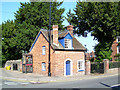
10

Phone box on South Parade
Taken from The Southend.
The house looks like a turnpike or toll house. If anyone has details please e-mail me and I will update the information.
Image: © Pauline E
Taken: 12 Jan 2008
0.25 miles