IMAGES TAKEN NEAR TO
Bromsberrow Heath, LEDBURY, HR8 1NX
Introduction
This page details the photographs taken nearby to HR8 1NX by members of the Geograph project.
The Geograph project started in 2005 with the aim of publishing, organising and preserving representative images for every square kilometre of Great Britain, Ireland and the Isle of Man.

There are currently over 7.5m images from over14,400 individuals and you can help contribute to the project by visiting https://www.geograph.org.uk
Image Map
Images are licensed for reuse under creativecommons.org/licenses/by-sa/2.0
Notes
- Clicking on the map will re-center to the selected point.
- The higher the marker number, the further away the image location is from the centre of the postcode.
Image Listing (32 Images Found)
Images are licensed for reuse under creativecommons.org/licenses/by-sa/2.0
Image
Details
Distance
1
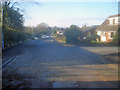
Sandfields at Bromesberrow Heath - 1
Looking west along this quiet looking village street, which runs parallel to the M50, so quiet it is not.
Image: © Trevor Rickard
Taken: 1 Jan 2010
0.03 miles
2
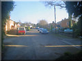
Sandfields at Bromesberrow Heath - 2
Looking east along Sandfields, a residential street off the main village street, but next to the motorway, which runs behind the houses on the right.
Image: © Trevor Rickard
Taken: 1 Jan 2010
0.04 miles
3
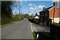
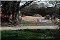
Bromesberrow Heath
There are a few of older houses in the small village of Bromesberrow Heath though there are a number of bungalows built in the 1960s and 70s.
Image: © Philip Halling
Taken: 4 Apr 2008
0.06 miles
4
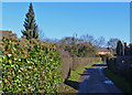
Bell Lane, Bromesberrow Heath
One of the confusingly discontiguous sections of Bell Lane.
Image: © John Allan
Taken: 17 Feb 2015
0.09 miles
5
Marie's floral memorial
The daffodils, just visible by telephoto setting, on the motorway bank are planted in the shape of a letter M. Marie Wilks was murdered in June 1988 as she waited by her broken-down car; the perpetrator has not been identified.
The incident occurred several miles east of this spot by the M50 near Bushley, Worcestershire.
Image: © Jonathan Billinger
Taken: 26 Mar 2008
0.14 miles
6
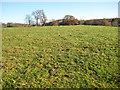
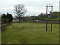
Sheep pasture, Bromesberrow Heath
Viewed from the lane north of the village.
Image: © Pauline E
Taken: 1 Dec 2008
0.14 miles
7
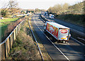
Cakes to the people
Traffic on the M50 heading east. To the left, the village of Bromesberrow Heath, shielded from some of the noise by the thick, wooden fence.
Image: © Pauline E
Taken: 1 Dec 2008
0.15 miles
8
Bromesberrow Quarry
Sand and gravel quarry on the edge of Bromesberrow Heath.
Image: © Philip Halling
Taken: 4 Apr 2008
0.15 miles
9
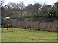
Land bordering the motorway
Scene at Bromsberrow Heath with the M50 passing across the picture behind the high wooden sound-barrier fence.
Image: © Jonathan Billinger
Taken: 26 Mar 2008
0.16 miles
10
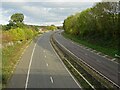
The M50 motorway passing Bromesberrow Heath
Opened in 1960 the M50 was one of Britain's earliest motorways, being an important link between the then coalfields of South Wales, and the industrial midlands around Birmingham and the Black Country.
Image: © Philip Halling
Taken: 22 Oct 2020
0.16 miles