IMAGES TAKEN NEAR TO
Upperfields, LEDBURY, HR8 1LE
Introduction
This page details the photographs taken nearby to Upperfields, HR8 1LE by members of the Geograph project.
The Geograph project started in 2005 with the aim of publishing, organising and preserving representative images for every square kilometre of Great Britain, Ireland and the Isle of Man.

There are currently over 7.5m images from over14,400 individuals and you can help contribute to the project by visiting https://www.geograph.org.uk
Image Map
Images are licensed for reuse under creativecommons.org/licenses/by-sa/2.0
Notes
- Clicking on the map will re-center to the selected point.
- The higher the marker number, the further away the image location is from the centre of the postcode.
Image Listing (146 Images Found)
Images are licensed for reuse under creativecommons.org/licenses/by-sa/2.0
Image
Details
Distance
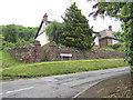
1
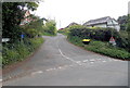
Upperfields, Ledbury
Viewed from Knapp Lane. Upperfields is a 300 metre long residential cul-de-sac at the western edge of Dog Hill Wood.
Image: © Jaggery
Taken: 19 May 2013
0.04 miles
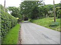
2
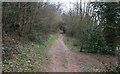
Path Through Dog Hill Wood
This path is very close to the edge of the wood and runs close to the houses in the Upperfields area of Ledbury.
Image: © Bob Embleton
Taken: 18 Feb 2007
0.04 miles
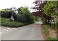
3
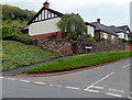
Corner of Bank Crescent and Knapp Lane, Ledbury
Bank Crescent houses viewed from Knapp Lane.
Image: © Jaggery
Taken: 19 May 2013
0.05 miles
4
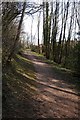
The Herefordshire Trail
The Herefordshire Trail passing through Dog Hill Wood above Ledbury.
Image: © Philip Halling
Taken: 26 Mar 2018
0.06 miles
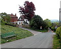
5
Hillside homes, Bank Crescent, Ledbury
Bank Crescent sits below Dog Hill Wood.
Image: © Pauline E
Taken: 30 May 2008
0.07 miles
6
Knapp Lane, Ledbury, climbs to Dog Hill Wood
A steep incline - the seat was a welcome sight.
Image: © Pauline E
Taken: 30 May 2008
0.07 miles
7
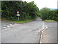
Knapp Lane, Ledbury
Knapp Lane descends from the corner of Upperfields. http://www.geograph.org.uk/photo/3468463
The triangular sign on the left shows No footway for 250 yds.
Image: © Jaggery
Taken: 19 May 2013
0.08 miles
8
Knapp Lane bench, Ledbury
No room for pavements here, but there is a bench at the side of the road.
Image: © Jaggery
Taken: 19 May 2013
0.08 miles
9
Crossroads off Knapp Lane, Ledbury
To the left, Bank Crescent; to the right, Knapp Ridge. The road drops steeply into the town and is a popular cut through to the A449, Worcester Road.
Image: © Pauline E
Taken: 30 May 2008
0.09 miles
10
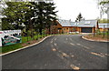
Lark Rise, Ledbury
Lark Rise is a new development of 5 houses on the north side of Knapp Lane.
Image: © Jaggery
Taken: 19 May 2013
0.09 miles