IMAGES TAKEN NEAR TO
HR7 4UX
Introduction
This page details the photographs taken nearby to HR7 4UX by members of the Geograph project.
The Geograph project started in 2005 with the aim of publishing, organising and preserving representative images for every square kilometre of Great Britain, Ireland and the Isle of Man.

There are currently over 7.5m images from over14,400 individuals and you can help contribute to the project by visiting https://www.geograph.org.uk
Image Map
Images are licensed for reuse under creativecommons.org/licenses/by-sa/2.0
Notes
- Clicking on the map will re-center to the selected point.
- The higher the marker number, the further away the image location is from the centre of the postcode.
Image Listing (13 Images Found)
Images are licensed for reuse under creativecommons.org/licenses/by-sa/2.0
Image
Details
Distance
2
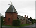
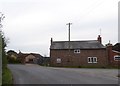
Hop kiln, Stocks
Beside the B4214, Munderfield Stocks.
Image: © Richard Webb
Taken: 3 Apr 2019
0.04 miles
3
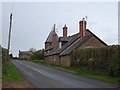
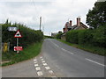
B4214 at Munderfield Stocks
An oast house by the road indicates the importance of hops to this part of Herefordshire in the past.
Image: © Jonathan Billinger
Taken: 30 Jan 2007
0.04 miles
4
Oast House, Stocks Farm, Munderfield Stocks
Image: © Oast House Archive
Taken: 30 Aug 2015
0.04 miles
5
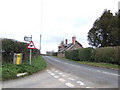
Road junction in Munderfield Stocks
The old house at the road junction contrasts with the modern bungalow
Image: © David Smith
Taken: 20 Oct 2017
0.05 miles
6
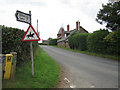
Munderfield Stocks junction, looking north
Image: © Peter Whatley
Taken: 22 Jul 2008
0.06 miles
7
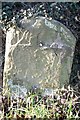
Old Milestone by the B4214, Munderfield Stocks, Avenbury parish
Metal plate (lost) attached to stone post by the B4214, in parish of AVENBURY (District), Munderfield Stocks, by the West side of road. Bromyard iron plate, erected by the Bromyard turnpike trust in the 19th century.
Inscription once read:-
(TO)
(BROMYARD)
(3)
(MILES)
Herefordshire SMR.
SMR Number: 56534 https://www.heritagegateway.org.uk/Gateway/Results_Single.aspx?uid=MHE28291&resourceID=101
Milestone Society National ID: HF_BYLD03.
Image: © Robert Walker
Taken: 14 Jan 2012
0.07 miles
8
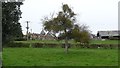
Stocks Farm
Like most farms here, it had hop kilns.
Image: © Richard Webb
Taken: 3 Apr 2019
0.08 miles
9
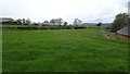
Stocks Farm
A contrast from the previous year, warm weather got the grass growing fast and early in 2019. Shame about the snow later in the day.
Image: © Richard Webb
Taken: 3 Apr 2019
0.11 miles
10
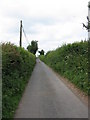
Stoke Lane
The lane from Munderfield to all the Stokes (Stoke Lane, Stoke Cross and Stoke Lacy).
Image: © Peter Whatley
Taken: 22 Jul 2008
0.12 miles