IMAGES TAKEN NEAR TO
Lammas Close, LEOMINSTER, HR6 8NU
Introduction
This page details the photographs taken nearby to Lammas Close, HR6 8NU by members of the Geograph project.
The Geograph project started in 2005 with the aim of publishing, organising and preserving representative images for every square kilometre of Great Britain, Ireland and the Isle of Man.

There are currently over 7.5m images from over14,400 individuals and you can help contribute to the project by visiting https://www.geograph.org.uk
Image Map
Images are licensed for reuse under creativecommons.org/licenses/by-sa/2.0
Notes
- Clicking on the map will re-center to the selected point.
- The higher the marker number, the further away the image location is from the centre of the postcode.
Image Listing (229 Images Found)
Images are licensed for reuse under creativecommons.org/licenses/by-sa/2.0
Image
Details
Distance

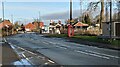
2
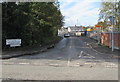
Waterworks Lane, Leominster
The eastern end of Waterworks Lane viewed across Worcester Road.
Image: © Jaggery
Taken: 16 Oct 2019
0.12 miles
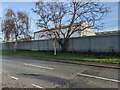
3
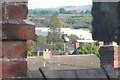
BPI (Leominster)
Leominster's bad luck, viewed from the roof at my granddad's house.
Image: © Fabian Musto
Taken: 27 Sep 2018
0.13 miles
4
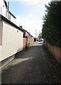
Northern end of Caswell Crescent, Leominster
Looking south from Etnam Street.
Image: © Jaggery
Taken: 16 Oct 2019
0.14 miles
5
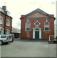
Grade II listed Leominster Baptist Church
Set back 20 metres from the south side of Etnam Street. The year 1771 is inscribed above the bulls-eye window above the doorway. Grade II listed in July 1954.
Image: © Jaggery
Taken: 22 Apr 2012
0.14 miles
6
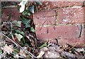
Ordnance Survey Cut Mark
This OS cut mark can be found on a brick post north of the footpath. It marks a point 74.972m above mean sea level.
Image: © Adrian Dust
Taken: 12 Mar 2017
0.14 miles
7
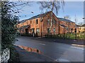
Veterans' homes (Leominster)
This self-built housing development was completed in December 2020. I remember there was an older building on the site until it was demolished in the early 2010s, and that was the Bramley Business Park. This housing also replaced late 20th century housing (out-of-shot) to the left of this photo, and this project was reported by BBC News after the housing was completed in December 2020. The veterans that once struggled with civilian life (some were homeless) now live in these great houses and their service to the country has been acknowledged.
Image: © Fabian Musto
Taken: 3 Feb 2021
0.14 miles
8
Former Countrywide Country Store (Leominster)
Weeks before I moved out of my old house, I took a short walk around the town, including a detour to see the Pinsley Mill Gardens housing in development. I remember passing this store on that day in March 2017 and the sign was faded. Four years later, the sign is now gone and it is not occupied by a business as of 2021. The building is adjacent to the railway station and I only took one photo of a then active Countrywide Country Store three years ago Image
Image: © Fabian Musto
Taken: 3 Feb 2021
0.15 miles
10
Worcester Road (Leominster)
The tall brick towers in the distance are part of Pinsley Mill Gardens, a housing development built on the site of one of the world's earliest cotton mills. To the right of it is the White Lion pub, then the railway station sign for Leominster can be seen in front, and closer to the camera to the right is an active K6 telephone box.
Image: © Fabian Musto
Taken: 3 Feb 2021
0.15 miles