1
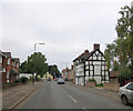
Nos. 29 and 31, Mill Street
The two 'black and white' cottages date from the 17th C. and are Grade II listed with English Heritage Building ID: 459753.
Image: © Stuart Logan
Taken: 22 Sep 2013
0.02 miles
2
The side of the old Hop Pole pub, Leominster
This is where the car park was, as you can see it's all now redundant.
Image: © David Howard
Taken: 11 May 2019
0.02 miles
3
The Hop Pole (Leominster)
This pub closed around two years ago, and even by now they still have not done anything to the site.
Image: © Fabian Musto
Taken: 2 Mar 2018
0.03 miles
4
The Hop Pole (Leominster)
Two years later after my last photo of the pub (
Image ), the building now looks like this. The attaching buildings to the left have now been demolished, and the main building has been refurbished. I saw foundations of a new building out-of-shot to the left.
Image: © Fabian Musto
Taken: 11 Jul 2020
0.04 miles
5
Development at the former Hop Pole (Leominster)
The former Hop Pole inn is now being converted into private housing as of 2020, and when I last photographed this view in July
Image the two brick walls weren't in front of the structure before, although they were erected in mid August.
Image: © Fabian Musto
Taken: 20 Sep 2020
0.04 miles
6
The Hop Pole pub, Leominster
Despite the sign it's been closed for at least a year
Image: © David Howard
Taken: 11 May 2019
0.05 miles
7
Mill Street (Leominster)
Here is Mill Street, viewed from a path that is along the street.
Why is it called Mill Street? Well because back then, where I stood to take this photograph was where a small mill stream used to be, but was replaced in the 1960s since it mostly flooded the town a lot and the mill stream here was blamed for it.
You also notice that not a lot of houses are here. Well, same reason as above, they were demolished in the 1960s, and only left a couple of old buildings standing, such as No.29-31 Mill Street on the right. Those two are Grade II listed.
In the distance, behind the modern housing on the left is a former pub called "The Golden Lion", which is now a private house.
Image: © Fabian Musto
Taken: 2 Mar 2018
0.05 miles
8
Sign at The Hop Pole (Leominster)
Just imagine if someone entered the pub by looking at the sign without knowing that it is actually closed. Well, to make people not enter, the gates are closed due to obvious reasons. Anyways, here is a sign at The Hop Pole, which looks alright.
Image: © Fabian Musto
Taken: 2 Mar 2018
0.05 miles
9
The Hop Pole (Leominster)
Here is The Hop Pole public house, which closed two years ago around 2016. It still looks alright, but the windows have seen better days.
Image: © Fabian Musto
Taken: 20 Jun 2018
0.05 miles
10
The Hop Pole (Leominster)
Here is the Hop Pole public house, which closed back in 2016. Viewed from the A44 road. In the future, this will be converted into flats.
Image: © Fabian Musto
Taken: 1 Jul 2018
0.05 miles


