IMAGES TAKEN NEAR TO
Hope-under-Dinmore, LEOMINSTER, HR6 0PU
Introduction
This page details the photographs taken nearby to HR6 0PU by members of the Geograph project.
The Geograph project started in 2005 with the aim of publishing, organising and preserving representative images for every square kilometre of Great Britain, Ireland and the Isle of Man.

There are currently over 7.5m images from over14,400 individuals and you can help contribute to the project by visiting https://www.geograph.org.uk
Image Map
Images are licensed for reuse under creativecommons.org/licenses/by-sa/2.0
Notes
- Clicking on the map will re-center to the selected point.
- The higher the marker number, the further away the image location is from the centre of the postcode.
Image Listing (12 Images Found)
Images are licensed for reuse under creativecommons.org/licenses/by-sa/2.0
Image
Details
Distance
1
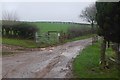
Road off Westhope Hill
The start of the tar.
Image: © Richard Webb
Taken: 27 Dec 2015
0.11 miles
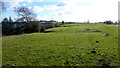
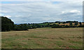
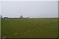
2
Eastern edge of Westhope Common
Following the track to large barns at Broomwell Farm just below. Queen's Wood on the next hill and the Malvern Hills on the horizon.
Image: © Trevor Rickard
Taken: 20 Oct 2010
0.13 miles
3
Westhope Common, 2
Looking south from next to Broomwell Farm towards the end of the common land's 'tail'.
Image: © Jonathan Billinger
Taken: 14 Jan 2016
0.14 miles
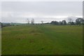
4
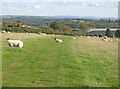
Westhope Common, 6
Grassland on the crest of Westhope Hill.
The farmer is taking feed out to the sheep.
Image: © Jonathan Billinger
Taken: 14 Jan 2016
0.15 miles
5
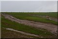
Westhope Common, 8
Pictured from the eastern access point by Broomwell Farm.
The many tracks have been unnecessarily left by thoughtless off-roaders.
Image: © Jonathan Billinger
Taken: 14 Jan 2016
0.16 miles
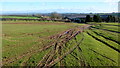
6
Track on Westhope Hill
The mapped track is just flattened grass. This is the top of one of Herefordshire's many flat topped sandstone hills.
Image: © Richard Webb
Taken: 27 Dec 2015
0.16 miles
8
Tracks, Westhope Hill
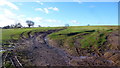
Very muddy and within seconds of taking this I ended up sat down in it.
Image: © Richard Webb
Taken: 27 Dec 2015
0.17 miles
9
Westhope Common, 7
Grassland on the crest of Westhope Hill.
Looking east towards Broomwell Farm.
The multiple tracks were created by irresponsible off-roaders.
Image: © Jonathan Billinger
Taken: 14 Jan 2016
0.17 miles
10
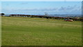
On Westhope Hill
Westhope Common occupies the summit plateau of a steep sided sandstone hill.
Image: © Richard Webb
Taken: 27 Dec 2015
0.23 miles