IMAGES TAKEN NEAR TO
Eyton, LEOMINSTER, HR6 0AQ
Introduction
This page details the photographs taken nearby to HR6 0AQ by members of the Geograph project.
The Geograph project started in 2005 with the aim of publishing, organising and preserving representative images for every square kilometre of Great Britain, Ireland and the Isle of Man.

There are currently over 7.5m images from over14,400 individuals and you can help contribute to the project by visiting https://www.geograph.org.uk
Image Map
Images are licensed for reuse under creativecommons.org/licenses/by-sa/2.0
Notes
- Clicking on the map will re-center to the selected point.
- The higher the marker number, the further away the image location is from the centre of the postcode.
Image Listing (10 Images Found)
Images are licensed for reuse under creativecommons.org/licenses/by-sa/2.0
Image
Details
Distance
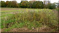
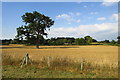
2
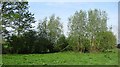
Roadside grassland, Eyton
Probably a narrow common, but not marked as "access" land on the 1:25,000 map. This is a strip of grassland and wetland willow woods alongside a minor road.
Image: © Richard Webb
Taken: 23 Apr 2011
0.07 miles
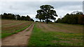
3
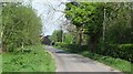
Lane to Eyton
Part of Gilbert's Farm can be seen.
Image: © Jonathan Billinger
Taken: 13 Oct 2017
0.17 miles
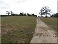
4
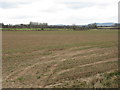
Uncultivated headland
An area left for wildlife which runs parallel with the field edge.
Image: © Jonathan Billinger
Taken: 13 Oct 2017
0.17 miles
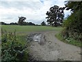
5
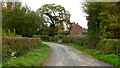
Concrete farm track
This private track services fields to the north of Gilbert's Farm.
Image: © Jonathan Billinger
Taken: 13 Oct 2017
0.19 miles
7
Farmland in the Lugg valley
Farmland in the Lugg valley, a footpath follows the track.
Image: © Philip Halling
Taken: 12 Oct 2016
0.21 miles
8
Farmland at Eyton
Looking northeast from the Lugg
Image: © Z Pryce
Taken: 26 Jul 2018
0.21 miles
9
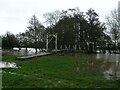
Floods on the River Lugg - December 2012
This rickety suspension bridge between Eyton and Kingsland has survived many years of floods, often higher than this one.
Image: © Z Pryce
Taken: 22 Dec 2012
0.22 miles