IMAGES TAKEN NEAR TO
Waterside, HEREFORD, HR4 7ET
Introduction
This page details the photographs taken nearby to Waterside, HR4 7ET by members of the Geograph project.
The Geograph project started in 2005 with the aim of publishing, organising and preserving representative images for every square kilometre of Great Britain, Ireland and the Isle of Man.

There are currently over 7.5m images from over14,400 individuals and you can help contribute to the project by visiting https://www.geograph.org.uk
Image Map
Images are licensed for reuse under creativecommons.org/licenses/by-sa/2.0
Notes
- Clicking on the map will re-center to the selected point.
- The higher the marker number, the further away the image location is from the centre of the postcode.
Image Listing (6 Images Found)
Images are licensed for reuse under creativecommons.org/licenses/by-sa/2.0
Image
Details
Distance
1

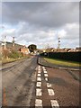
Site of Credenhill station, 1986
View eastward, towards Hereford: ex-Midland Hereford - Brecon line, closed entirely 31/12/62. The new buildings on the site are the Credenhill Sports and Social Club and may be connected with the RAF Camp at Credenhill.
Image: © Ben Brooksbank
Taken: 22 Jun 1986
0.11 miles
2

Social club at Credenhill
The focus of this picture taken from the old railway bridge was to be the course of the former Hereford to Brecon railway though there is little evidence now with a social club built on the former track bed.
Image: © Philip Halling
Taken: 9 Jan 2011
0.11 miles
3
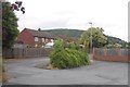
Station Road, Credenhill
Service housing from when the RAF were here.
Image: © Richard Webb
Taken: 19 Jul 2019
0.14 miles
4
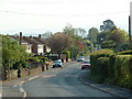
Credenhill Village
Credenhill village, taken from near to the community centre
Image: © Phil Bufton
Taken: 11 Jan 2006
0.17 miles
5
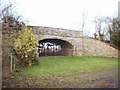
Disused Railway bridge
Disused railway bridge at Credenhill
Image: © Phil Bufton
Taken: 11 Jan 2006
0.17 miles