IMAGES TAKEN NEAR TO
Eardisley, HEREFORD, HR3 6PP
Introduction
This page details the photographs taken nearby to HR3 6PP by members of the Geograph project.
The Geograph project started in 2005 with the aim of publishing, organising and preserving representative images for every square kilometre of Great Britain, Ireland and the Isle of Man.

There are currently over 7.5m images from over14,400 individuals and you can help contribute to the project by visiting https://www.geograph.org.uk
Image Map
Images are licensed for reuse under creativecommons.org/licenses/by-sa/2.0
Notes
- Clicking on the map will re-center to the selected point.
- The higher the marker number, the further away the image location is from the centre of the postcode.
Image Listing (92 Images Found)
Images are licensed for reuse under creativecommons.org/licenses/by-sa/2.0
Image
Details
Distance
1
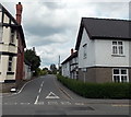
Almeley Road, Eardisley
Viewed across the A4111 Church Road. The New Strand http://www.geograph.org.uk/photo/3529292 is on the left. The sign on the right shows 2 miles to Almeley.
Image: © Jaggery
Taken: 26 Jun 2013
0.06 miles
2
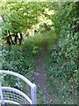
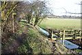
Kington Tramway
Now but a humble footpath, this section of the long-abandoned tramway is raised up on a causeway immediately east of the village of Eardisley.
Image: © Alan Bowring
Taken: 25 Jul 2015
0.09 miles
3
Footpath north from the Almeley Road
Path leads north along Holywell Dingle towards Lemore Manor.
Image: © Jonathan Billinger
Taken: 10 Feb 2016
0.10 miles
4
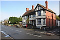
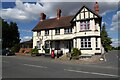
The Strand in Eardisley
The Strand public house in Eardisley, previously it has been called 'The Mountie' and 'The New Inn'. The pub is situated on the main street in Eardisley. Note the US Jeep parked in front.
Image: © Philip Halling
Taken: 28 Jan 2012
0.10 miles
5
Former tramway, Eardisley
The Kington Tramway was an early narrow gauge horse tramway that linked limestone quarries at Burlinjob in Radnorshire to Eardisley. The tramway dates from 1818 when it received parliamentary authorisation. Its gauge was 3ft 6in. The Kington Tramway was acquired by the Kington and Eardisley Railway in 1862.
Image: © Philip Halling
Taken: 28 Jan 2012
0.11 miles
6
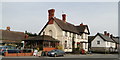
New Strand Inn, Eardisley
Formerly just the New Inn, but now a little-bit-of-everything business, including the Post Office. Directly opposite the Tram Inn.
Image: © Philip Pankhurst
Taken: 24 Apr 2010
0.11 miles
7
The New Strand in Eardisley
Looking like a pub, the website describes is as 'restaurant, Bookshop, Pub and Post Office all in one'.
Image: © Philip Halling
Taken: 25 Aug 2022
0.11 miles
8
The New Strand in Eardisley
The Strand public house in Eardisley, previously it has been called 'The Mountie' and 'The New Inn'. The pub is situated on the main street in Eardisley
Image: © Philip Halling
Taken: 25 Aug 2022
0.11 miles
9
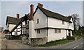
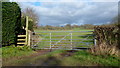
Upper House Farm, Eardisley
A gem of a medieval house at the entrance to the village. In need of some loving care and attention. Equally ancient barns to the rear.
Image: © Philip Pankhurst
Taken: 24 Apr 2010
0.11 miles
10
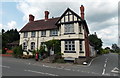
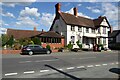
The New Strand, Eardisley
Located on the corner of Church Road and Almeley Road. A local guide to the village states that
The New Strand is a cafe with a take-away menu available, a public house and a secondhand book shop with a stock of 30,000 books. Some other references state that The New Strand is also the village post office, though there was no post office signage visible in this late June 2013 view. The year AD 1902 is written in white on a black beam above the upstairs window on the right.
Image: © Jaggery
Taken: 26 Jun 2013
0.11 miles