IMAGES TAKEN NEAR TO
Almeley, HEREFORD, HR3 6LD
Introduction
This page details the photographs taken nearby to HR3 6LD by members of the Geograph project.
The Geograph project started in 2005 with the aim of publishing, organising and preserving representative images for every square kilometre of Great Britain, Ireland and the Isle of Man.

There are currently over 7.5m images from over14,400 individuals and you can help contribute to the project by visiting https://www.geograph.org.uk
Image Map (Loading...)


Getting Data...Please wait
Leaflet Map data © OpenStreetMap
Images are licensed for reuse under creativecommons.org/licenses/by-sa/2.0
Notes
- Clicking on the map will re-center to the selected point.
- The higher the marker number, the further away the image location is from the centre of the postcode.
Image Listing (220 Images Found)
Images are licensed for reuse under creativecommons.org/licenses/by-sa/2.0
Image
Details
Distance
1
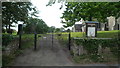
Entrance Gates to St. Mary the Virgin Church (Almeley)
Image: © Fabian Musto
Taken: 21 Aug 2019
0.00 miles
2
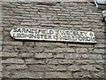
Fingerpost on Motte House (Almeley)
There are two vintage fingerposts on Motte House, and this sign informs the person that Sarnesfield is three miles away, Weobley is six miles away, Leominster is thirteen miles away and Hereford is fifteen miles away. This photograph was taken on a country lane that heads east out of Almeley.
Image: © Fabian Musto
Taken: 22 Dec 2021
0.00 miles
3
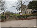
Entrance gates to St. Mary's church (Almeley)
The wrought iron entrance gates in the distance provides access to St. Mary's parish church from the east, and the gates also had a wreath like Image
Image: © Fabian Musto
Taken: 22 Dec 2021
0.00 miles
4
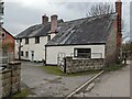
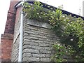
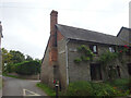
Motte House (Almeley)
This stone building was possibly built in the 18th or 19th century, and is situated opposite the parish church of St. Mary and the earthworks of Almeley Castle.
Image: © Fabian Musto
Taken: 22 Dec 2021
0.01 miles
5
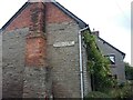
Direction Sign – Signpost on Motte House in Almeley
Fixed at first floor level to the west facing wall of Motte House at first floor level on the southeast corner of the T junction at the south end of the village in Almeley parish. 1 arm only. See also https://www.geograph.org.uk/photo/7581897 and https://www.geograph.org.uk/photo/4320089.
Milestone Society National ID: HF_SO3351A
Image: © A Milton
Taken: 6 Aug 2023
0.01 miles
6
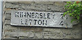
Direction Sign, Almley
Opposite the church on the house "Motte", it is also opposite the field with a motte & bailey in very recognisable preserve.
Context view is Image
Inscription: Kinnersley 2½ / Letton 4½
Milestone Society National ID: HF_SO3351A
Image: © Mr Red
Taken: 25 Aug 2023
0.01 miles
7
Road signs, Almeley
Fingers without the post.
Image: © Richard Webb
Taken: 29 Jun 2014
0.01 miles
8
Direction Sign – Signpost on Motte House in Almeley
Fixed at first floor level to the north facing wall of Motte House on the southeast corner of the T junction at the south end of the village in Almeley parish. 1 arm only.
See also https://www.geograph.org.uk/photo/7581891 , https://www.geograph.org.uk/photo/7051666 and https://www.geograph.org.uk/photo/4320089.
Milestone Society National ID: HF_SO3351B
Image: © A Milton
Taken: 6 Aug 2023
0.01 miles
9
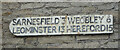
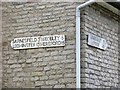
Direction Sign, Almley
Opposite the church in the minor road leading NE to the village hall. On the house "Motte", it is also opposite the field with a motte & bailey in very recognisable preserve.
Context view is Image
Inscription: Sarnsfiels 3 Weobly 6 / Leominster 13 Hereford 15
Milestone Society National ID: HF_SO3351B
Image: © Mr Red
Taken: 25 Aug 2023
0.01 miles
10
Two Direction Signs, Almley
Opposite the church and the field with a recognisable motte & bailey.
Close-up views of the signs are: Image & Image
Image: © Mr Red
Taken: 25 Aug 2023
0.01 miles