IMAGES TAKEN NEAR TO
Dorstone, HEREFORD, HR3 6AW
Introduction
This page details the photographs taken nearby to HR3 6AW by members of the Geograph project.
The Geograph project started in 2005 with the aim of publishing, organising and preserving representative images for every square kilometre of Great Britain, Ireland and the Isle of Man.

There are currently over 7.5m images from over14,400 individuals and you can help contribute to the project by visiting https://www.geograph.org.uk
Image Map
Images are licensed for reuse under creativecommons.org/licenses/by-sa/2.0
Notes
- Clicking on the map will re-center to the selected point.
- The higher the marker number, the further away the image location is from the centre of the postcode.
Image Listing (133 Images Found)
Images are licensed for reuse under creativecommons.org/licenses/by-sa/2.0
Image
Details
Distance
2
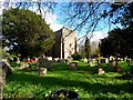
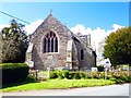
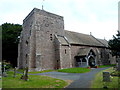
St Faith's church, Dorstone
This church was built in 1889. There have been three churches on this site. The first was built in 1256 by the family of one of the killers (Richard de Brito) of Thomas a Becket. The second church was built in 1827 and was replaced by this structure.
Image: © Bikeboy
Taken: 8 Apr 2014
0.02 miles
3
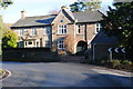
Grade II listed The Court House, Dorstone
Located facing a sharp bend in the B4348, the detached house is of two periods. The northern half dates from the 18th century. The southern half is Edwardian (early 20th century).
Grade II listed in February 1993.
Image: © Jaggery
Taken: 16 Sep 2012
0.02 miles
4
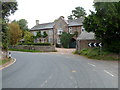
Unusual road sign, Dorstone
Viewed along the B4348 on the approach to a sharp bend in front of The Court House. http://www.geograph.org.uk/photo/3148664
The sign consists of 3 rows of 7 red discs arranged horizontally on a chequered black and white background.
Image: © Jaggery
Taken: 16 Sep 2012
0.02 miles
5
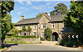
Court House, Dorstone
Elegant house on a wicked bend in the road to the East of the church. Late 17th century, tarted up in Victorian times according to the latest Pevsner.
Image: © Philip Pankhurst
Taken: 21 Jun 2013
0.03 miles
6
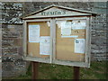
Sign at St. Faith's Church (Dorstone)
A couple of notices are seen on this sign, and the text "St. Faith's" looks like it is about to wear off completely.
Image: © Fabian Musto
Taken: 23 Jun 2018
0.03 miles
7
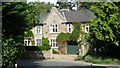
The Court House (Dorstone)
What a fine stone structure this is!
Image: © Fabian Musto
Taken: 23 Jun 2018
0.03 miles
8
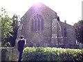
St. Faith's Church (Dorstone)
Here is St. Faith's Church at Dorstone, which the present structure we see here was built in 1889, due to the previous structure (1827) having huge negative reviews on it. My brother is seen taking a photo of the church.
Image: © Fabian Musto
Taken: 23 Jun 2018
0.03 miles
9
St Faith's Church
Grade II* listed parish church dating from the 14th century but substantially rebuilt in the 19th century
Image: © Graham Hogg
Taken: 26 Apr 2016
0.03 miles
10
Dorstone church viewed from the SW
St Faith's Church Dorstone is one of eight churches in the Church of England Borderlink Group of parishes. This church is the fourth one to occupy this site. The first one was built in the 12th century. The second one was a chapel founded in 1256. This one survived until 1827. The third church lasted only 60 years because of poor construction. The current church, in the Early English style, dates from 1889.
Image: © Jaggery
Taken: 16 Sep 2012
0.03 miles