IMAGES TAKEN NEAR TO
Glasbury, HEREFORD, HR3 5NP
Introduction
This page details the photographs taken nearby to HR3 5NP by members of the Geograph project.
The Geograph project started in 2005 with the aim of publishing, organising and preserving representative images for every square kilometre of Great Britain, Ireland and the Isle of Man.

There are currently over 7.5m images from over14,400 individuals and you can help contribute to the project by visiting https://www.geograph.org.uk
Image Map
Images are licensed for reuse under creativecommons.org/licenses/by-sa/2.0
Notes
- Clicking on the map will re-center to the selected point.
- The higher the marker number, the further away the image location is from the centre of the postcode.
Image Listing (75 Images Found)
Images are licensed for reuse under creativecommons.org/licenses/by-sa/2.0
Image
Details
Distance
1
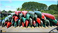
Wye Valley Canoes
Some of the boats for hire at Wye Valley Canoes. The canoe business at Glasbury Bridge was opened in 2000 by Jane Hughes who has added a cafe and bunkhouse to the site.
Image: © Mark Percy
Taken: 23 Jul 2018
0.02 miles
2
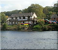
Wye Valley Canoe Centre, Glasbury
Viewed across the River Wye. Glasbury Bridge http://www.geograph.org.uk/photo/3202903 is just out of shot on the right.
Image: © Jaggery
Taken: 11 Sep 2011
0.03 miles
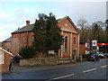
3
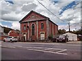
The Former Treble Hill Baptist Chapel, Glasbury
Image: © Chris Andrews
Taken: 15 Aug 2023
0.04 miles
4
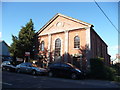
Old chapel in Glasbury-on-Wye
Recently on the market and now sold by the look of it. Would make a great cafe - or home.
Image: © Jeremy Bolwell
Taken: 14 Oct 2012
0.04 miles
5
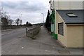
Road and adjacent path in Glasbury
The path and road (A438) are approaching Glasbury Bridge over the River Wye at Glasbury, a village which appears to be in both England and Wales, (the river being the boundary). The view is from the English side where the village post office is in view.
Image: © Trevor Littlewood
Taken: 8 Mar 2005
0.05 miles
6
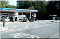
Glasbury Service Station
Located on the east bank of the River Wye, at the junction of the A438 and the B4350.
Image: © Jaggery
Taken: 11 Sep 2011
0.05 miles
7
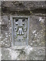
Ordnance Survey Flush Bracket (11631)
This OS Flush Bracket can be found on the pillar of the bridge, SW side of the road. It marks a point 85.879m above mean sea level.
Image: © Adrian Dust
Taken: 8 Jun 2014
0.05 miles
8
Chapel by Glasbury Bridge
I thought this looked disused until I saw a new-looking sign on the door advertising a service on November 8th.
Image: © Ruth Sharville
Taken: 25 Nov 2009
0.05 miles
9
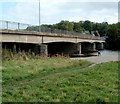
South side of Glasbury Bridge
Glasbury Bridge carries the A438 across the River Wye.
This bridge was built in 1923. Several of its predecessors were destroyed by the Wye in flood.
Image: © Jaggery
Taken: 11 Sep 2011
0.05 miles
10
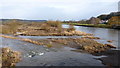
The Wye from Glasbury Bridge, 2
The river widens considerably here and forms a large shingle island.
Image: © Jonathan Billinger
Taken: 29 Jan 2015
0.06 miles