IMAGES TAKEN NEAR TO
HR1 9JJ
Introduction
This page details the photographs taken nearby to HR1 9JJ by members of the Geograph project.
The Geograph project started in 2005 with the aim of publishing, organising and preserving representative images for every square kilometre of Great Britain, Ireland and the Isle of Man.

There are currently over 7.5m images from over14,400 individuals and you can help contribute to the project by visiting https://www.geograph.org.uk
Image Map
Images are licensed for reuse under creativecommons.org/licenses/by-sa/2.0
Notes
- Clicking on the map will re-center to the selected point.
- The higher the marker number, the further away the image location is from the centre of the postcode.
Image Listing (49 Images Found)
Images are licensed for reuse under creativecommons.org/licenses/by-sa/2.0
Image
Details
Distance
1
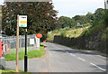
Pontrilas by the Post Office
On the edge of this village looking towards Hereford.
Image: © roger geach
Taken: 1 Sep 2012
0.03 miles
2
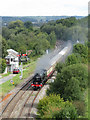
Steam railtour at Pontrilas
Saphos Trains' Welsh Marches Express from Liverpool to Cardiff is seen approaching Pontrilas on the outward leg with rebuilt Royal Scot-class 4-6-0 No. 46100 'Royal Scot' in charge.
Image: © Gareth James
Taken: 5 Sep 2020
0.03 miles
3
Pontrilas Post Office
Located near the eastern edge of the village, at the entrance to Pontrilas Business Park, near the A465 junction. Although the name Pontrilas is of Welsh origin (there are many such place names in western Herefordshire), the village is about a mile on the English side of the border. Compare the simple 'Post Office' here with the bilingual sign at Mardy post office http://www.geograph.org.uk/photo/2580861 about 10 miles away, in Wales.
The former Pontrilas post office http://www.geograph.org.uk/photo/2593060 is about 70 metres to the west.
Image: © Jaggery
Taken: 6 Sep 2011
0.03 miles
4
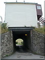
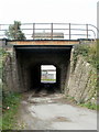
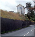
Signal box on a bridge, Pontrilas
The bridge carries the Welsh Marches railway line over a minor road in the village of Pontrilas, Herefordshire. Unusually, there is a signal box on the bridge. The box was built in 1880. Though Pontrilas station closed in 1964, the signal box is still in use, to control the points and semaphore signals in the area.
Image: © Jaggery
Taken: 6 Sep 2011
0.03 miles
5
Signal box and railway bridge viewed from the south, Pontrilas
The top of the signal box can be seen behind railings. The opposite view http://www.geograph.org.uk/photo/2589127 shows the side of the signal box. The bridge carries the Welsh Marches railway lines.
Image: © Jaggery
Taken: 6 Sep 2011
0.03 miles
6
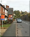
Main road through Pontrilas
There are houses on only one side of the unnamed road through the village in this section. On the other side is the high boundary wall of the Welsh Marches railway line. Visible above the wall, centre right, are two red semaphore signals, controlled by a signal box http://www.geograph.org.uk/photo/2589127 on a small bridge. The white edge of the signal box can be seen in the distance.
Image: © Jaggery
Taken: 6 Sep 2011
0.03 miles
7
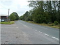
A465 heads west along the edge of Pontrilas
Viewed from the junction with the road through Pontrilas. The A465 heads towards the B4347 junction for Ewyas Harold, then, after crossing the River Monnow into Wales, heads for Abergavenny.
Image: © Jaggery
Taken: 6 Sep 2011
0.03 miles
8
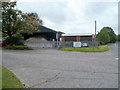
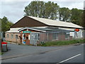
Eastern edge of Pontrilas Business Park
Viewed from the corner of the A465. A Herefordshire Council Property Services notice on the fence on the right states that light industrial units are available.
There is a good supply of rock salt in the Roads Department premises on the left. After three snowier than average winters in a row, staff who grit the roads are probably hoping for a less snowy winter in 2011-2012 !
Image: © Jaggery
Taken: 6 Sep 2011
0.03 miles
9
Unusual signal box, Pontrilas
This view of the signal box from the east doesn't show anything unusual. It's only as you get nearer that you see it's built on a bridge. http://www.geograph.org.uk/photo/2589127
Image: © Jaggery
Taken: 6 Sep 2011
0.03 miles
10
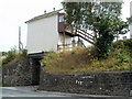
Pontrilas signal box viewed from the west
Steps lead up to the signal box, which controls the points and semaphore signals on the local stretch of the Welsh Marches railway line. Unusually, the signal box is built on a bridge. http://www.geograph.org.uk/photo/2589127
Image: © Jaggery
Taken: 6 Sep 2011
0.03 miles