IMAGES TAKEN NEAR TO
Brockhampton, HEREFORD, HR1 4TJ
Introduction
This page details the photographs taken nearby to HR1 4TJ by members of the Geograph project.
The Geograph project started in 2005 with the aim of publishing, organising and preserving representative images for every square kilometre of Great Britain, Ireland and the Isle of Man.

There are currently over 7.5m images from over14,400 individuals and you can help contribute to the project by visiting https://www.geograph.org.uk
Image Map
Images are licensed for reuse under creativecommons.org/licenses/by-sa/2.0
Notes
- Clicking on the map will re-center to the selected point.
- The higher the marker number, the further away the image location is from the centre of the postcode.
Image Listing (53 Images Found)
Images are licensed for reuse under creativecommons.org/licenses/by-sa/2.0
Image
Details
Distance
1
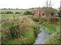
Small stream at Totnor, near Brockhampton
Seen from the Wye Valley Walk, this stream, unnamed on the OS maps, flows into the River Wye less than 2km downstream (behind the camera).
The house in the foreground has seen better days.
Image: © David Purchase
Taken: 10 Nov 2014
0.01 miles
2
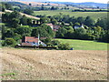
Totnor hamlet
Cluster of houses which provided range of services for Brockhampton, including smithy. Hills above Ross on the horizon.
Image: © David M Clark
Taken: 2 Sep 2005
0.02 miles
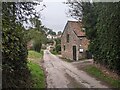
3
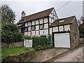
Blacksmiths Cottage (Totnor)
This timber-framed structure was possibly built in the sixteenth or seventeenth century, and it does not have listed status as of October 2023.
Image: © Fabian Musto
Taken: 12 Oct 2023
0.02 miles
4
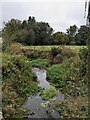
Stream at Totnor
This stream is a tributary of the River Wye at How Caple.
Image: © Fabian Musto
Taken: 12 Oct 2023
0.02 miles
6
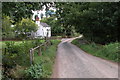
Cottage in Totnor
This is one of the few cottages in Totnor near Brockhampton. The Wye Valley Walk follows this lane on its route from the river's estuary to its source.
Image: © Philip Halling
Taken: 17 Sep 2005
0.03 miles
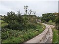
7
The hamlet of Totnor
The Wye Valley Walk passes through this hamlet on the country lane seen in this photo, and the settlement is situated between Brockhampton (north) and How Caple (south).
Image: © Fabian Musto
Taken: 12 Oct 2023
0.03 miles
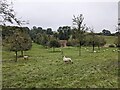
8
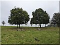
Trees at Totnor
The trees in this view are part of an orchard at Totnor, viewed from a public footpath to Brockhampton.
Image: © Fabian Musto
Taken: 12 Oct 2023
0.05 miles
9

Lane at Totnor
This country lane also carries the Wye Valley Walk.
Image: © Fabian Musto
Taken: 12 Oct 2023
0.06 miles
10
House at Totnor
The house in the distance is listed as a pumping station on the OS map, but it looked like a private house when we walked by.
Image: © Fabian Musto
Taken: 12 Oct 2023
0.06 miles