IMAGES TAKEN NEAR TO
Dymond Close, HEREFORD, HR1 2RP
Introduction
This page details the photographs taken nearby to Dymond Close, HR1 2RP by members of the Geograph project.
The Geograph project started in 2005 with the aim of publishing, organising and preserving representative images for every square kilometre of Great Britain, Ireland and the Isle of Man.

There are currently over 7.5m images from over14,400 individuals and you can help contribute to the project by visiting https://www.geograph.org.uk
Image Map
Images are licensed for reuse under creativecommons.org/licenses/by-sa/2.0
Notes
- Clicking on the map will re-center to the selected point.
- The higher the marker number, the further away the image location is from the centre of the postcode.
Image Listing (73 Images Found)
Images are licensed for reuse under creativecommons.org/licenses/by-sa/2.0
Image
Details
Distance
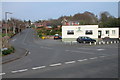
1
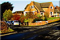
Sunlit corner in Hereford
Early rain in Hereford on January 8th 2015 soon cleared to give a mild, sunny, springlike day.
This is the junction of Sedgefield Road (on the left) and Lichfield Avenue.
Image: © Jaggery
Taken: 8 Jan 2015
0.05 miles
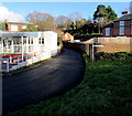
2
Lichfield Avenue, Hereford
A recreation of the first picture submitted in this grid square, submitted by me 16 years ago in April 2006 Image Little has changed in the intervening 16 years. The building housing the veterinary practice has change colour and the streetlamps have been replaced.
Image: © Philip Halling
Taken: 25 Jun 2022
0.05 miles
3
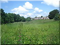
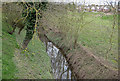
Wasteland by the Eign Brook
From Hampton Park Road looking north along the small stream valley. The stream is in the trees to the left and the houses of Sedgefield Road are to the right. This area is flood plain and is not built upon.
Image: © Trevor Rickard
Taken: 7 Jun 2008
0.06 miles
4
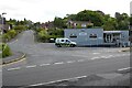
The entrance to Sedgefield Road
This is a quiet residential suburb east of the city centre.
Image: © Peter Mackenzie
Taken: 3 Oct 2017
0.07 miles
6
Old Eign Hill, Hereford
Old Eign Hill begins its ascent from the B4224 junction, past Brookfield Veterinary Practice http://www.geograph.org.uk/photo/4305207
on the left and Beech House Nursery School http://www.geograph.org.uk/photo/4305199 on the right.
Image: © Jaggery
Taken: 8 Jan 2015
0.08 miles
7
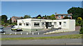
Brookfield Veterinery Practice
Situated off Old Eign Hill to the east of Hereford city centre.
Image: © Jonathan Billinger
Taken: 9 Jun 2008
0.08 miles
8
Lichfield Avenue, Hereford
Lichfield Avenue at its junction with Eign Road in Hereford. The white building in the foreground is a veterinary practice.
Image: © Philip Halling
Taken: 22 Apr 2006
0.08 miles
9
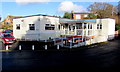
Brookfield Vets in Hereford
Brookfield Veterinary Practice is at 1 Old Eign Hill, near the B4224 and the River Wye.
Image: © Jaggery
Taken: 8 Jan 2015
0.08 miles
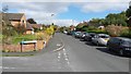
10
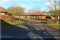
Burrows Court, Hereford
Bungalows on the north side of the B4224 Eign Road.
Image: © Jaggery
Taken: 8 Jan 2015
0.09 miles