IMAGES TAKEN NEAR TO
Quay Street, HEREFORD, HR1 2NH
Introduction
This page details the photographs taken nearby to Quay Street, HR1 2NH by members of the Geograph project.
The Geograph project started in 2005 with the aim of publishing, organising and preserving representative images for every square kilometre of Great Britain, Ireland and the Isle of Man.

There are currently over 7.5m images from over14,400 individuals and you can help contribute to the project by visiting https://www.geograph.org.uk
Image Map
Images are licensed for reuse under creativecommons.org/licenses/by-sa/2.0
Notes
- Clicking on the map will re-center to the selected point.
- The higher the marker number, the further away the image location is from the centre of the postcode.
Image Listing (2129 Images Found)
Images are licensed for reuse under creativecommons.org/licenses/by-sa/2.0
Image
Details
Distance
1
Hereford: Quay Street meets Castle Hill
A man walks into Quay Street from Image The houses in the foreground are in Castle Hill and the tower of the cathedral is in the distance.
Image: © Chris Downer
Taken: 17 Dec 2007
0.01 miles
2
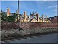
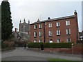
Hereford Cathedral School
Two grade II listed structures from this view; the brick wall and cathedral school (School House). The structure was built as a house in the late 18th century, though it is now part of Hereford Cathedral School. The bell tower of Hereford Cathedral is seen in the background, which is grade I listed.
Image: © Fabian Musto
Taken: 8 Jul 2021
0.01 miles
3
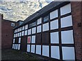
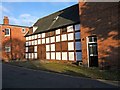
St. Ethelbert's (Stable wing | Hereford)
Next to the Georgian house of St. Ethelbert's (late 18th century) is this timber-framed stable wing, which was built in the 17th century. The building now houses a tuck shop for the adjacent cathedral school.
Image: © Fabian Musto
Taken: 8 Jul 2021
0.01 miles
5
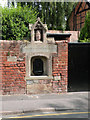
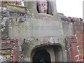
St Ethelbert's Well
... which is quite surprising, given he was martyred 1200 years ago!
C19 cast-iron drinking fountain in ashlar niche with chamfered 4-centred arch; badly weathered C14 head of crowned king, over (said to be from destroyed west front of Cathedral). Restored 1977. Grade II listed, ref. 372265. http://www.britishlistedbuildings.co.uk/en-372265-saint-ethelbert-s-well-hereford-
Image: © Keith Edkins
Taken: 15 Jul 2013
0.01 miles
6
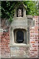
Site of St Ethelbert's Well
St Ethelbert is thought to have been murdered at King Offa's palace at Sutton Walls, north of Hereford. This well is near Castle Green to the east of the cathedral which is part dedicated to St Ethelbert.
Image: © Philip Halling
Taken: 25 Jun 2022
0.01 miles
7
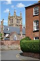
View of the tower of Hereford Cathedral
Viewed from the approach to the Castle Green, the Cathedral tower is viewed over the roof of the College of the Vicar's Choral.
Image: © Philip Halling
Taken: 25 Jun 2022
0.01 miles
8
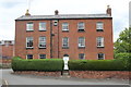
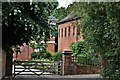
St Ethelbert's, Hereford
Grade II listed. Listing number 1205870. House. Late C18/early C19 with earlier features.
Image: © Andrew Abbott
Taken: 25 May 2019
0.01 miles
9
Old building, Quay Street
Quay Street is very near the cathedral. This building appears to be several hundred years old, and unusually has shutters over the ground floor windows. It is not clear what it originally was. There is a pole over the entrance doors, from which presumably a sign once hung. Maybe it was once a shop or a pub, or perhaps a stables?
Image: © P L Chadwick
Taken: 2 Jan 2010
0.02 miles
10
"The Site of St. Ethelbert's Well" (Hereford)
A close-up of St. Ethelbert's Well, showing the text on the plaque. The title says it all.
Image: © Fabian Musto
Taken: 10 Mar 2018
0.02 miles