IMAGES TAKEN NEAR TO
Garnstone Rise, HEREFORD, HR1 1PW
Introduction
This page details the photographs taken nearby to Garnstone Rise, HR1 1PW by members of the Geograph project.
The Geograph project started in 2005 with the aim of publishing, organising and preserving representative images for every square kilometre of Great Britain, Ireland and the Isle of Man.

There are currently over 7.5m images from over14,400 individuals and you can help contribute to the project by visiting https://www.geograph.org.uk
Image Map
Images are licensed for reuse under creativecommons.org/licenses/by-sa/2.0
Notes
- Clicking on the map will re-center to the selected point.
- The higher the marker number, the further away the image location is from the centre of the postcode.
Image Listing (5 Images Found)
Images are licensed for reuse under creativecommons.org/licenses/by-sa/2.0
Image
Details
Distance
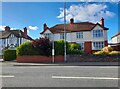
1
The White House (Tupsley)
Not to be confused with the famous White House at America.
The White House Community Hub used to be a pub in its former days, opening around the mid 1960s I believe. It closed around the 2010s and shortly afterwards it was converted into another use.
Image: © Fabian Musto
Taken: 23 May 2018
0.07 miles
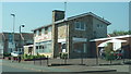
3
Pigott Close, Hereford
Adjacent to the college campus
Image: © Z Pryce
Taken: 28 Jun 2022
0.20 miles
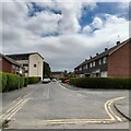
4
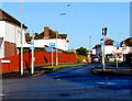
One way system, Monk Crescent, Hereford
Looking north from the Ledbury Road end.
Image: © Jaggery
Taken: 8 Jan 2015
0.22 miles