IMAGES TAKEN NEAR TO
Oxford Road, BEACONSFIELD, HP9 1UB
Introduction
This page details the photographs taken nearby to Oxford Road, HP9 1UB by members of the Geograph project.
The Geograph project started in 2005 with the aim of publishing, organising and preserving representative images for every square kilometre of Great Britain, Ireland and the Isle of Man.

There are currently over 7.5m images from over14,400 individuals and you can help contribute to the project by visiting https://www.geograph.org.uk
Image Map
Images are licensed for reuse under creativecommons.org/licenses/by-sa/2.0
Notes
- Clicking on the map will re-center to the selected point.
- The higher the marker number, the further away the image location is from the centre of the postcode.
Image Listing (45 Images Found)
Images are licensed for reuse under creativecommons.org/licenses/by-sa/2.0
Image
Details
Distance
1
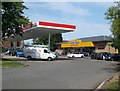
Holtspur: Esso service station
The service station is on the A40 Oxford Road and offers all the usual facilities, including the bizarrely named "On the Run" franchise. (Think about the various connotations!)
Image: © Nigel Cox
Taken: 26 Jul 2014
0.00 miles
2
Harvester pub on A40, western outskirts of Beaconsfield
Image: © Bikeboy
Taken: 23 Jun 2012
0.02 miles
3

Beaconsfield fire station
Beaconsfield fire station, 2 Skelton Close, Beaconsfield, Buckinghamshire
Image: © Kevin Hale
Taken: 13 Nov 2006
0.04 miles
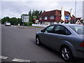
5
Shops in Holtspur Top Lane, Beaconsfield
There are more shops round the corner in Heath Road. Those in the photo include a post office, and a printing and graphics business.
Image: © David Hawgood
Taken: 7 Aug 2008
0.06 miles
8
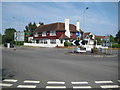
Holtspur: King's Head
Victorian Ordnance Survey maps show that Holtspur was then really not a lot more than the King's Head, presumably a coaching inn on the main route connecting London and Oxford, and a now long-lost brick works. Today the King's Head is a Harvester restaurant on the A40 (the Harvester Beaconsfield), but you would struggle to see evidence of its original name (it's there in red under the dark green oval Harvester sign, if you look closely, but sadly lacking the apostrophe). See http://www.harvester.co.uk/harvesterbeaconsfieldholtspur/ for details.
Another sign of the times is the advert for hot tubs on the roundabout.
Image: © Nigel Cox
Taken: 26 Jul 2014
0.07 miles
10
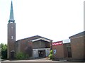
Holtspur: The Church of St Thomas
With the post-war spread of Beaconsfield and the swallowing up of the hamlet of Holtspur the need for a church was perceived as urgent and a structure was first built here, on Mayflower Way, for that purpose in 1949. The present-day church building seen here dates from 1961. The site was once inside the curtilage of the old brick works that extended southwards to the road between London and Oxford.
(Photographer's note. No amount of digital manipulation will turn this photo into anything worth looking at! It's the wrong view at the wrong time of day and in the worst lighting conditions. Apologies but at the time of writing it is the only photo of the church on the website.)
Image: © Nigel Cox
Taken: 26 Jul 2014
0.10 miles