IMAGES TAKEN NEAR TO
Moneybury Hill, BERKHAMSTED, HP4 1LX
Introduction
This page details the photographs taken nearby to Moneybury Hill, HP4 1LX by members of the Geograph project.
The Geograph project started in 2005 with the aim of publishing, organising and preserving representative images for every square kilometre of Great Britain, Ireland and the Isle of Man.

There are currently over 7.5m images from over14,400 individuals and you can help contribute to the project by visiting https://www.geograph.org.uk
Image Map
Images are licensed for reuse under creativecommons.org/licenses/by-sa/2.0
Notes
- Clicking on the map will re-center to the selected point.
- The higher the marker number, the further away the image location is from the centre of the postcode.
Image Listing (155 Images Found)
Images are licensed for reuse under creativecommons.org/licenses/by-sa/2.0
Image
Details
Distance
1
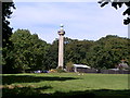
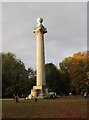
Bridgewater Monument
A less familiar angle, the monument is seen here from woodland away from the main picnic area.
Image: © Peter S
Taken: 8 Sep 2012
0.06 miles
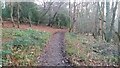
2
Pit on Aldbury Common
The 1st Edition OS map shows this as a disused chalk pit. The Chalk Rock - a hard band at the base of the Upper Chalk - crops out here, and probably furnished hard chunks of chalk for burning to lime, probably used agriculturally in the Aylesbury Vale.
Image: © Dylan Moore
Taken: 20 Jan 2014
0.06 miles
3
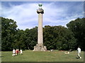
Bridgewater Monument, Ashridge Estate
The 108 feet high monument was built in memory of Francis Egerton, the third duke of Bridgewater. Ease of access by road makes this a popular spot for summer picnics.
Image: © Peter S
Taken: 8 Sep 2012
0.07 miles
5
View of Ashridge Monument, Autumn morning
Image: © Dylan Moore
Taken: 19 Nov 2005
0.08 miles
6
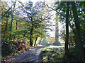
Bridleway to Aldbury
From Moneybury Hill the bridleway down to Aldbury
Image: © Shaun Ferguson
Taken: 15 Dec 2020
0.10 miles
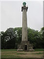
8
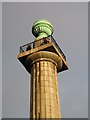
The Bridgewater Monument
The Bridgewater Monument is a tower on the Ashridge estate, Hertfordshire, built in 1832 in memory of Francis Egerton, 3rd Duke of Bridgewater, "the father of inland navigation". It is 108 feet (33 m) tall, with 170 steps inside, designed by Sir Jeffry Wyattville in a Doric style. It overlooks the village of Aldbury and the Grand Union Canal.
See also . . . Image, Image, Image, Image, Image, Image
Image: © Gerald Massey
Taken: 25 Oct 2009
0.12 miles
9
The Bridgewater Monument
The Bridgewater Monument is a tower on the Ashridge estate, Hertfordshire, built in 1832 in memory of Francis Egerton, 3rd Duke of Bridgewater, "the father of inland navigation". It is 108 feet (33 m) tall, with 170 steps inside, designed by Sir Jeffry Wyattville in a Doric style. It overlooks the village of Aldbury and the Grand Union Canal.
See also . . . Image, Image, Image, Image, Image, Image
Image: © Gerald Massey
Taken: 25 Oct 2009
0.12 miles
10
The Bridgewater Monument
The Bridgewater Monument is a tower on the Ashridge estate, Hertfordshire, built in 1832 in memory of Francis Egerton, 3rd Duke of Bridgewater, "the father of inland navigation". It is 108 feet (33 m) tall, with 170 steps inside, designed by Sir Jeffry Wyattville in a Doric style. It overlooks the village of Aldbury and the Grand Union Canal.
See also . . . Image, Image, Image, Image, Image, Image
Image: © Gerald Massey
Taken: 25 Oct 2009
0.12 miles