IMAGES TAKEN NEAR TO
Boundary Way, HEMEL HEMPSTEAD, HP2 7SS
Introduction
This page details the photographs taken nearby to Boundary Way, HP2 7SS by members of the Geograph project.
The Geograph project started in 2005 with the aim of publishing, organising and preserving representative images for every square kilometre of Great Britain, Ireland and the Isle of Man.

There are currently over 7.5m images from over14,400 individuals and you can help contribute to the project by visiting https://www.geograph.org.uk
Image Map (Loading...)


Getting Data...Please wait
Leaflet Map data © OpenStreetMap
Images are licensed for reuse under creativecommons.org/licenses/by-sa/2.0
Notes
- Clicking on the map will re-center to the selected point.
- The higher the marker number, the further away the image location is from the centre of the postcode.
Image Listing (18 Images Found)
Images are licensed for reuse under creativecommons.org/licenses/by-sa/2.0
Image
Details
Distance
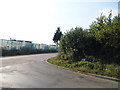
1
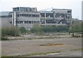
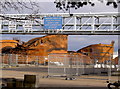
Buncefield: Three years and four months on (2)
Although most of the industrial buildings damaged during the explosion have been, or are, being repaired, and the most severely damaged ones have been demolished, some remain more or less as they were immediately after the explosion. This is the rear of one such building, viewed from Buncefield Lane, and the direction of the source of the explosion, across the car park of the now demolished Northgate Information Solutions building.
Image: © Nigel Cox
Taken: 12 Apr 2009
0.09 miles
2
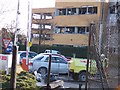
3-Com and Kodak office: Buncefield
Damage typical to nearby offices.
Image: © Denis Kelly
Taken: 17 Dec 2005
0.11 miles
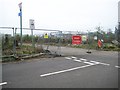
3
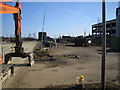
Hemel Hempstead: Buncefield Oil Storage Depot
View taken looking eastwards from Boundary Way, eleven weeks after the explosion on 11 December 2005. One small storage tank is standing but to the right of it are the remains of one of the burnt out larger tanks. The Northgate Information Solutions building, which was devastated by the explosion, was on the site on the left side of the view and has been demolished. Beyond the four concrete bollards the remains of a line of burnt out cars are still in place. For a summary of the event and its consequences the Wikipedia link is here http://en.wikipedia.org/wiki/2005_Hertfordshire_Oil_Storage_Terminal_fire
Image: © Nigel Cox
Taken: 25 Feb 2006
0.12 miles
4
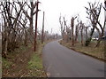
Trees in Buncefield Lane, Hemel Hempstead
Buncefield Lane runs along side Buncefield Oil Storage Depot. Over 13 months after the fire. The undergrowth has been recently cleared. There is still visible damage to the upper parts of the trees. The road has recently been re-surfaced.
Image: © Rob Emms
Taken: 5 Feb 2007
0.16 miles
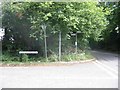
5
Cherry Tree Lane at the junction of Three Cherrytrees Lane
This is by the old Buncefield oil depot and looks suspiciously like the beginnings of another housing estate.
Image: © David Howard
Taken: 5 Sep 2013
0.18 miles
6
Buncefield: Three Cherry Trees Lane
Three years and four months after the Buncefield Oil Depot explosion and Three Cherry Trees Lane remains closed to the east of its junction with Buncefield Lane. The oil tank that first exploded would have been in the compound enclosed with the Y-shaped fence posts.
Image: © Nigel Cox
Taken: 12 Apr 2009
0.19 miles
7
Road sign Cherry Tree Lane.
I was amused by the degree of obscurity given by foliage to the road signs. Does anybody really care??
Image: © Jack Hill
Taken: 20 Aug 2005
0.20 miles
8
Oil Storage and filling point
This photo complements the one on the EWS next door.
Image: © Jack Hill
Taken: 20 Aug 2005
0.20 miles
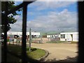
9
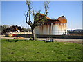
Buncefield Oil Storage Depot
Rusting oil tanks, thirteen months after the fire.
Image: © Rob Emms
Taken: 28 Jan 2007
0.20 miles
10
Hemel Hempstead: Buncefield Oil Storage Depot
Sixteen months after the explosion and fire the work of removing the debris goes on. The standing tank is No. 909 and to the left are the piled up rusting remains of one of the other tanks. What is remarkable is that the tree, despite being so close to the inferno, has survived and fresh greenery is beginning to appear. This photo was taken through the fence on Buncefield Lane which was closed to public access for about a year after the event.
Image: © Nigel Cox
Taken: 19 Apr 2007
0.20 miles