IMAGES TAKEN NEAR TO
Cuffley Court, HEMEL HEMPSTEAD, HP2 7LD
Introduction
This page details the photographs taken nearby to Cuffley Court, HP2 7LD by members of the Geograph project.
The Geograph project started in 2005 with the aim of publishing, organising and preserving representative images for every square kilometre of Great Britain, Ireland and the Isle of Man.

There are currently over 7.5m images from over14,400 individuals and you can help contribute to the project by visiting https://www.geograph.org.uk
Image Map (Loading...)


Getting Data...Please wait
Leaflet Map data © OpenStreetMap
Images are licensed for reuse under creativecommons.org/licenses/by-sa/2.0
Notes
- Clicking on the map will re-center to the selected point.
- The higher the marker number, the further away the image location is from the centre of the postcode.
Image Listing (12 Images Found)
Images are licensed for reuse under creativecommons.org/licenses/by-sa/2.0
Image
Details
Distance
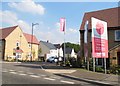
1
Hemel Hempstead: Berkeley Square
The Berkeley Square here is a residential development in the north-east corner of Hemel Hempstead, not the more widely known one in Mayfair.
Image: © Nigel Cox
Taken: 17 Dec 2020
0.07 miles
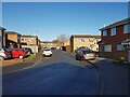
2
New housing on Cherry Tree Grove, Cupid Green
There appears to be a tax on window space from the look of these.
Image: © David Howard
Taken: 5 Sep 2013
0.16 miles
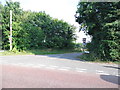
4
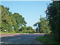
Crossroads on B487 Hemel Hempstead Road
Looking from Cherry Tree Lane across to Holtsmere End Lane.
Image: © Robin Webster
Taken: 6 Sep 2015
0.18 miles
5
Cherry Tree Lane at the junction of Redbourn Road
Image: © David Howard
Taken: 5 Sep 2013
0.19 miles
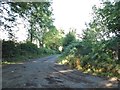
6
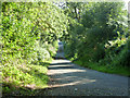
Lane towards Little Revel End
A through route to the B487, but hardly worth taking.
Image: © Robin Webster
Taken: 6 Sep 2015
0.19 miles
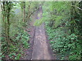
7
Hemel Hempstead: The Nicky Line
This is a same view, same viewpoint, same photographer image as Image] from 2009.
The spelling Nicky appears on a lot of old signage, but Nickey appears to now be the current vogue.
Image: © Nigel Cox
Taken: 17 Dec 2020
0.22 miles
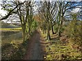
8
Hemel Hempstead: The Nicky Line
Viewed from Image this is the trackbed of the dismantled Hemel Hempstead to Harpenden railway (The Nicky Line), completed in 1877. Passenger services ceased in 1947 and the track was lifted in the late 1950s. The trackbed now forms a section of the National Cycle Network Route 57.
Image: © Nigel Cox
Taken: 12 Apr 2009
0.24 miles
9
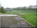
Hemel Hempstead: Cherry Tree Lane Flood Reservoir (2)
This is a flood reservoir, so presumably it is normally empty. It is about 180 metres long and about 70 metres wide. The trackbed of the former Hemel Hempstead to Harpenden railway, the Nicky Line, is just beyond the high bank to the right. The local government boundary between the Dacorum and St Albans council areas runs left to right across the middle of the reservoir.
Image: © Nigel Cox
Taken: 12 Apr 2009
0.24 miles
10
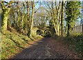
Hemel Hempstead: The Nicky Line
This is a near same view, near same viewpoint, same photographer image of the Cherry Tree Lane bridge as Image] from 2007.
As far as the photographer is aware, this section of the railway was only ever single track, so the purpose of the double arch in the bridge is unknown. Perhaps it was built with a planned expansion to double track in mind, but the doubling of the line never materialized.
The spelling Nicky appears on a lot of old signage, but Nickey appears to now be the current vogue.
Image: © Nigel Cox
Taken: 17 Dec 2020
0.25 miles