IMAGES TAKEN NEAR TO
Buncefield Terminal, Green Lane, HEMEL HEMPSTEAD, HP2 7JA
Introduction
This page details the photographs taken nearby to Buncefield Terminal, Green Lane, HP2 7JA by members of the Geograph project.
The Geograph project started in 2005 with the aim of publishing, organising and preserving representative images for every square kilometre of Great Britain, Ireland and the Isle of Man.

There are currently over 7.5m images from over14,400 individuals and you can help contribute to the project by visiting https://www.geograph.org.uk
Image Map
Images are licensed for reuse under creativecommons.org/licenses/by-sa/2.0
Notes
- Clicking on the map will re-center to the selected point.
- The higher the marker number, the further away the image location is from the centre of the postcode.
Image Listing (26 Images Found)
Images are licensed for reuse under creativecommons.org/licenses/by-sa/2.0
Image
Details
Distance
1
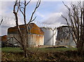
Buncefield Oil Storage Depot, Hemel Hempstead
Thirteen months after the fire.
Image: © Rob Emms
Taken: 28 Jan 2007
0.07 miles
2
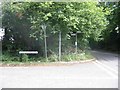
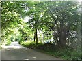
Road sign Cherry Tree Lane.
I was amused by the degree of obscurity given by foliage to the road signs. Does anybody really care??
Image: © Jack Hill
Taken: 20 Aug 2005
0.08 miles
3
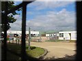
Oil Storage and filling point
This photo complements the one on the EWS next door.
Image: © Jack Hill
Taken: 20 Aug 2005
0.08 miles
4
Buncefield Oil Storage Depot
Rusting oil tanks, thirteen months after the fire.
Image: © Rob Emms
Taken: 28 Jan 2007
0.08 miles
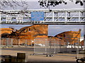
5
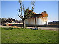
Hemel Hempstead: Buncefield Oil Storage Depot
Sixteen months after the explosion and fire the work of removing the debris goes on. The standing tank is No. 909 and to the left are the piled up rusting remains of one of the other tanks. What is remarkable is that the tree, despite being so close to the inferno, has survived and fresh greenery is beginning to appear. This photo was taken through the fence on Buncefield Lane which was closed to public access for about a year after the event.
Image: © Nigel Cox
Taken: 19 Apr 2007
0.08 miles
6
Buncefield Lane, Cupid Green
Running along the side of the oil depot which burnt down in 2006. Despite the rural appearance the depot is behind the railings on the right and an industrial estate behind the trees on the left.
Image: © David Howard
Taken: 5 Sep 2013
0.09 miles
7
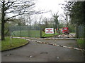
Buncefield: Emergency fire water pond (1)
Buncefield Oil Depot has several of these ponds scattered around the site. This one is on Buncefield Lane. Just how effective these ponds were in helping to deal with the disastrous explosion of 11 December 2005 is not known by an ordinary layman. Just over the boundary to the right is the site of the original Buncefield farm from which the oil depot got its name.
Image: © Nigel Cox
Taken: 12 Apr 2009
0.12 miles
8
Three Cherry Trees Lane
Considerably remodelled, with no trees, after the huge Buncefield oil depot fire in 2005 and in consequence several years of closure. The explosion and initial fires happened to the left, and eventually a large tank to the right also caught fire.
Image: © Robin Webster
Taken: 6 Sep 2015
0.14 miles
9
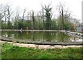
Buncefield: Emergency fire water pond (2)
This is a close-up view of the pond in Image
Image: © Nigel Cox
Taken: 12 Apr 2009
0.14 miles
10
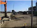
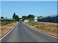
Hemel Hempstead: Buncefield Oil Storage Depot
View taken looking eastwards from Boundary Way, eleven weeks after the explosion on 11 December 2005. One small storage tank is standing but to the right of it are the remains of one of the burnt out larger tanks. The Northgate Information Solutions building, which was devastated by the explosion, was on the site on the left side of the view and has been demolished. Beyond the four concrete bollards the remains of a line of burnt out cars are still in place. For a summary of the event and its consequences the Wikipedia link is here http://en.wikipedia.org/wiki/2005_Hertfordshire_Oil_Storage_Terminal_fire
Image: © Nigel Cox
Taken: 25 Feb 2006
0.14 miles