IMAGES TAKEN NEAR TO
Wellington Avenue, PRINCES RISBOROUGH, HP27 9LA
Introduction
This page details the photographs taken nearby to Wellington Avenue, HP27 9LA by members of the Geograph project.
The Geograph project started in 2005 with the aim of publishing, organising and preserving representative images for every square kilometre of Great Britain, Ireland and the Isle of Man.

There are currently over 7.5m images from over14,400 individuals and you can help contribute to the project by visiting https://www.geograph.org.uk
Image Map
Images are licensed for reuse under creativecommons.org/licenses/by-sa/2.0
Notes
- Clicking on the map will re-center to the selected point.
- The higher the marker number, the further away the image location is from the centre of the postcode.
Image Listing (45 Images Found)
Images are licensed for reuse under creativecommons.org/licenses/by-sa/2.0
Image
Details
Distance
1
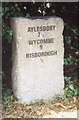
Old Milestone by the A4010 in Monks Risborough
Carved stone post by the A4010, in parish of Princes Risborough (Wycombe District), Aylesbury Road; Monks Risborough, at junction with Beach Court, half mile North East of town centre, in hedge behind footpath; by electricity pole, on West side of road. Wycombe rough stone post, erected by the Ellesborough to West Wycombe turnpike trust in the 19th century.
Inscription reads:-
AYLESBURY
7½
WYCOMBE
9
RISBOROUGH
½
Buckinghamshire HER.
HER Number: 1431800000 https://www.heritagegateway.org.uk/Gateway/Results_Single.aspx?uid=MBC33073&resourceID=1024
Milestone Society National ID: BU_WYAY09
Image: © A Rosevear & J Higgins
Taken: 3 Sep 2002
0.10 miles
2
Shortborough Avenue, Monks Risborough
Monks Risborough and Princes Risborough were originally separate communities but are now joined together by suburban housing.
Image: © Des Blenkinsopp
Taken: 19 Dec 2020
0.10 miles
3
Dunsmore Ride, Monks Risborough
Princes Risborough expanded significantly between about 1950 and 1980 including these houses here, which probably date from the late 1960s/early 1970s - part of an estate effectively joining Princes Risborough to Monks Risborough.
Image: © Stephen McKay
Taken: 24 Oct 2018
0.13 miles
4

Monks Risborough: Aylesbury Road
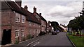
The main Aylesbury Road used to run in front of these houses but was moved away to the right in a road widening scheme, leaving a narrow slice of green, visible on the right. The white building is the former Nag's Head public house. All these buildings date from the 18th and 19th centuries and are within the Monks Risborough Conservation Area.
Image: © Nigel Cox
Taken: 30 Mar 2008
0.14 miles
5
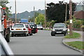
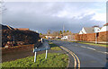
Wellington Avenue
Typical congestion at 3pm on a school day!
Image: © Tim S Addison
Taken: 7 Sep 2007
0.14 miles
6
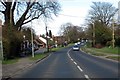
Aylesbury Road through Monks Risborough
Image: © Steve Daniels
Taken: 15 Mar 2014
0.15 miles
7
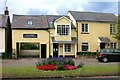
Flowers outside the Dentist's
Some of the older buildings of the original Monks Risborough village that are to be found in the area near the church.
Image: © Des Blenkinsopp
Taken: 7 Oct 2014
0.17 miles
8
Monks Risborough: Burton Lane (1)
Burton Lane contains the oldest residential buildings in Monks Risborough. The house on the left is timber framed with brick infill under a tiled roof and dates from around 1600. It is Grade II listed.
Image: © Nigel Cox
Taken: 30 Mar 2008
0.17 miles
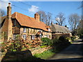
9
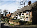
Monks Risborough: Burton Lane (2)
Burton Lane contains the oldest residential buildings in Monks Risborough. On the right are three cottages under a continuous thatched roof. The middle one dates from the 17th century, is timber framed, and has a section of the wattle and daub construction exposed behind a glass panel, visible over the door. The two outer cottages are later, and are built of brick and flint but all three are Grade II listed.
Image: © Nigel Cox
Taken: 30 Mar 2008
0.17 miles