IMAGES TAKEN NEAR TO
Wellington Avenue, PRINCES RISBOROUGH, HP27 9HY
Introduction
This page details the photographs taken nearby to Wellington Avenue, HP27 9HY by members of the Geograph project.
The Geograph project started in 2005 with the aim of publishing, organising and preserving representative images for every square kilometre of Great Britain, Ireland and the Isle of Man.

There are currently over 7.5m images from over14,400 individuals and you can help contribute to the project by visiting https://www.geograph.org.uk
Image Map
Images are licensed for reuse under creativecommons.org/licenses/by-sa/2.0
Notes
- Clicking on the map will re-center to the selected point.
- The higher the marker number, the further away the image location is from the centre of the postcode.
Image Listing (11 Images Found)
Images are licensed for reuse under creativecommons.org/licenses/by-sa/2.0
Image
Details
Distance
1
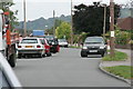
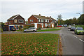
Wellington Avenue
Typical congestion at 3pm on a school day!
Image: © Tim S Addison
Taken: 7 Sep 2007
0.04 miles
2
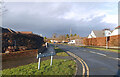
Shortborough Avenue, Monks Risborough
Monks Risborough and Princes Risborough were originally separate communities but are now joined together by suburban housing.
Image: © Des Blenkinsopp
Taken: 19 Dec 2020
0.05 miles
3
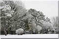
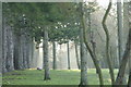
April snow King George V playing field
A late snowfall covered the Corsican pines and other trees on the north eastern border of the King George V playing field in Princes Risborough.
Image: © Tim S Addison
Taken: 6 Apr 2008
0.13 miles
4
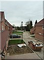
New houses in Princes Risborough
A view along the row of houses that form a new development of six properties by builders Matthew Homes Ltd in Princes Risborough. The view is from the first storey of the show home (Plot 2) looking northwestwards. As can be seen from the skip and muddy front garden, the site is yet to be completed.
The development replaces a single large house previously on the site, called "Longfield".
Image: © Rob Farrow
Taken: 4 Apr 2015
0.16 miles
5
Morning Mist King George V Playing Field
Image: © Tim S Addison
Taken: 27 Dec 2008
0.16 miles
6
Dunsmore Ride, Monks Risborough
Princes Risborough expanded significantly between about 1950 and 1980 including these houses here, which probably date from the late 1960s/early 1970s - part of an estate effectively joining Princes Risborough to Monks Risborough.
Image: © Stephen McKay
Taken: 24 Oct 2018
0.18 miles
7
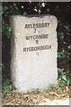
Old Milestone by the A4010 in Monks Risborough
Carved stone post by the A4010, in parish of Princes Risborough (Wycombe District), Aylesbury Road; Monks Risborough, at junction with Beach Court, half mile North East of town centre, in hedge behind footpath; by electricity pole, on West side of road. Wycombe rough stone post, erected by the Ellesborough to West Wycombe turnpike trust in the 19th century.
Inscription reads:-
AYLESBURY
7½
WYCOMBE
9
RISBOROUGH
½
Buckinghamshire HER.
HER Number: 1431800000 https://www.heritagegateway.org.uk/Gateway/Results_Single.aspx?uid=MBC33073&resourceID=1024
Milestone Society National ID: BU_WYAY09
Image: © A Rosevear & J Higgins
Taken: 3 Sep 2002
0.19 miles
8
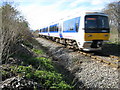
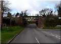
Monks Risborough: Railway line from Princes Risborough
A northbound Chiltern Railways train from Princes Risborough heading for Aylesbury is about to cross the pedestrian crossing from Westmead to Alscot Farm.
Image: © Nigel Cox
Taken: 30 Mar 2008
0.21 miles
9
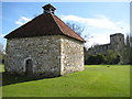
Monks Risborough Dovecote and Church
The dovecote is thought to date from the 16th century, and was originally a building on Place Farm, which was demolished in the 1970s for housing development.
Dovecotes were built by landowners to house rock pigeons. The pigeons would breed between April and October and the young birds, called squabs, would be taken when about four weeks old to be cooked and eaten. The design of dovecotes has always tried to appeal to pigeons and to discourage birds of prey, although modifications were sometimes needed to cope with the later threat posed by brown rats which could burrow into dovecotes and attack nests close to the ground.
This particular dovecote was constructed of chalk and originally would have had about 200 nestboxes.
(Notes loosely transcribed, with thanks, from the nearby information board written by the Princes Risborough Area Heritage Society.)
Image is in the background.
From a cartographic point of view the dovecote somewhat surprisingly merits its own pale orange "building" on the Ordnance Survey 1:50,000 scale mapping.
Image: © Nigel Cox
Taken: 30 Mar 2008
0.24 miles
10
Railway bridge, Monks Risborough
Single track railway which opened in 1868.
Image: © Bikeboy
Taken: 23 Mar 2014
0.24 miles