IMAGES TAKEN NEAR TO
Almond Way, PRINCES RISBOROUGH, HP27 9EB
Introduction
This page details the photographs taken nearby to Almond Way, HP27 9EB by members of the Geograph project.
The Geograph project started in 2005 with the aim of publishing, organising and preserving representative images for every square kilometre of Great Britain, Ireland and the Isle of Man.

There are currently over 7.5m images from over14,400 individuals and you can help contribute to the project by visiting https://www.geograph.org.uk
Image Map
Images are licensed for reuse under creativecommons.org/licenses/by-sa/2.0
Notes
- Clicking on the map will re-center to the selected point.
- The higher the marker number, the further away the image location is from the centre of the postcode.
Image Listing (63 Images Found)
Images are licensed for reuse under creativecommons.org/licenses/by-sa/2.0
Image
Details
Distance
2
New houses on Poppy Road, Princes Risborough
Image: © David Howard
Taken: 10 Aug 2017
0.10 miles
3
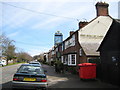
Princes Risborough: The Bird in Hand public house
This Greene King pub is on the east side of the B4444 Station Road in the Parkfield area of Princes Risborough. The 1878 Ordnance Survey map of the area shows Parkfield to be a triangular shaped settlement, quite discrete from Princes Risborough, and bounded on its three side by the Wycombe Road, Station Road and Poppy Road, and then by fields beyond the roads.
Image: © Nigel Cox
Taken: 30 Mar 2008
0.10 miles
4
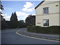
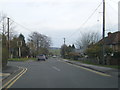
Poppy Road at the junction of Station Road
Image: © David Howard
Taken: 10 Aug 2017
0.11 miles
6
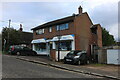
The Soft Water Shop on Station Road, Princes Risborough
Image: © David Howard
Taken: 27 Sep 2022
0.12 miles
7
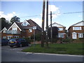
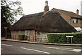
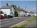
Houses on Station Road, Princes Risborough
Image: © David Howard
Taken: 10 Aug 2017
0.12 miles
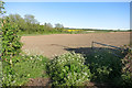
10
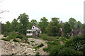
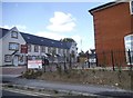
Demolition at Princes Risborough
The remaining fragment of the factory that stood outside Princes Risborough station.
Image: © Robert Eva
Taken: 11 May 2017
0.16 miles