IMAGES TAKEN NEAR TO
Woodway, PRINCES RISBOROUGH, HP27 0NN
Introduction
This page details the photographs taken nearby to Woodway, HP27 0NN by members of the Geograph project.
The Geograph project started in 2005 with the aim of publishing, organising and preserving representative images for every square kilometre of Great Britain, Ireland and the Isle of Man.

There are currently over 7.5m images from over14,400 individuals and you can help contribute to the project by visiting https://www.geograph.org.uk
Image Map
Images are licensed for reuse under creativecommons.org/licenses/by-sa/2.0
Notes
- Clicking on the map will re-center to the selected point.
- The higher the marker number, the further away the image location is from the centre of the postcode.
Image Listing (8 Images Found)
Images are licensed for reuse under creativecommons.org/licenses/by-sa/2.0
Image
Details
Distance
4
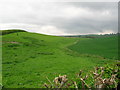
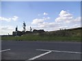
Dry valley north of Woodway
Looking east from Wycombe Road along an asymmetric dry valley. The steeper south-facing as permanent pasture and the shallow north-facing side winter wheat.
Image: © Simon Mortimer
Taken: 8 May 2006
0.18 miles
6
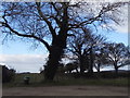
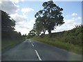
Trees by Shootacre Lane, Princes Risborough
Image: © David Howard
Taken: 20 Mar 2016
0.20 miles
7
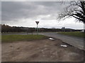
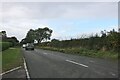
Shootacre Lane at the junction of Wycombe Road
Image: © David Howard
Taken: 20 Mar 2016
0.20 miles
8
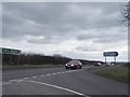
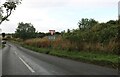
Wycombe Road at the junction of Shootacre Lane
Image: © David Howard
Taken: 20 Mar 2016
0.21 miles