IMAGES TAKEN NEAR TO
Little Park, PRINCES RISBOROUGH, HP27 0HS
Introduction
This page details the photographs taken nearby to Little Park, HP27 0HS by members of the Geograph project.
The Geograph project started in 2005 with the aim of publishing, organising and preserving representative images for every square kilometre of Great Britain, Ireland and the Isle of Man.

There are currently over 7.5m images from over14,400 individuals and you can help contribute to the project by visiting https://www.geograph.org.uk
Image Map
Images are licensed for reuse under creativecommons.org/licenses/by-sa/2.0
Notes
- Clicking on the map will re-center to the selected point.
- The higher the marker number, the further away the image location is from the centre of the postcode.
Image Listing (81 Images Found)
Images are licensed for reuse under creativecommons.org/licenses/by-sa/2.0
Image
Details
Distance
1
Princes Risborough: Former Berryfield Road Infants' School (1)
The School, which is shown on all the current OS maps, has been razed to the ground, and a 90 room care home for older people is under construction on the site. At first I thought this was an illustration of changing population demographics with fewer school children and more elderly people being needed to be provided for, but looking at Buckinghamshire Local Education Authority's formal closure notice for the School it appears that the purpose was to provide a new 360 place infants' school in the grounds of the local junior school, Icknield Junior, in Wellington Avenue, in line with the County Council's policy of amalgamating infant and junior schools where possible because it means fewer changes and more stability for children. From the closure notice it appears that the intention was to close the school with effect from 31 December 2001.
Image: © Nigel Cox
Taken: 30 Mar 2008
0.06 miles
2
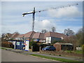
Princes Risborough: Former Berryfield Road Infants' School (2)
See Image for details. This is the care home under construction, viewed from outside the site gates. The notice board outside the site states "A Housing Solutions development of a 90 room care home for older people built in Partnership with Buckinghamshire County Council and The Fermantle (sic) Trust." It is to be hoped that the building work is better than the spelling! The Fremantle (for it is they) Trust http://www.fremantletrust.co.uk/cgi-bin/cp-app.cgi?usr=51F248515&rnd=6030878&rrc=N&affl=&cip=&act=&aff= is a not-for-profit provider of high quality care and support services, currently employing about 1,500 people.
Image: © Nigel Cox
Taken: 30 Mar 2008
0.06 miles
3
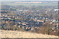
Princes Risborough
The town viewed from the Brush Hill Nature Reserve at the top of Kop Hill
Image: © Tim S Addison
Taken: 29 Jan 2006
0.07 miles
4
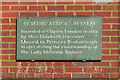
St Scholastica's Retreat inscription
This is on the wall of one of the houses run by a charitable trust. SeeImage for context.
Image: © Des Blenkinsopp
Taken: 17 Feb 2015
0.07 miles
5
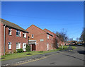
St Scholastica's Retreat
St Scholastica's Retreat is a Catholic housing charity founded in London in 1862.
The charity moved to Princes Risborough in 1972 and provides sheltered accommodation in these houses.
Image: © Des Blenkinsopp
Taken: 17 Feb 2015
0.07 miles
7
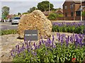
Princes Risborough - Pudding Stone
A lump of conglomerate, perhaps an ancient waymarker and now sited at the corner of Bell Street and New Road.
Image: © Colin Smith
Taken: 16 Aug 2016
0.08 miles
8
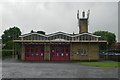
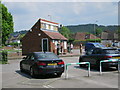
Princes Risborough fire station
Princes Risborough fire station, New Street, Princes Risborough, Buckinghamshire, complete with scaffolding
Image: © Kevin Hale
Taken: 18 Jun 2007
0.10 miles
9
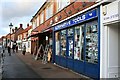
Alternative Tools
A small hardware shop on High Street Princes Risborough.
Image: © David Lally
Taken: 25 Nov 2009
0.11 miles