IMAGES TAKEN NEAR TO
Normandy Court, HEMEL HEMPSTEAD, HP2 5PZ
Introduction
This page details the photographs taken nearby to Normandy Court, HP2 5PZ by members of the Geograph project.
The Geograph project started in 2005 with the aim of publishing, organising and preserving representative images for every square kilometre of Great Britain, Ireland and the Isle of Man.

There are currently over 7.5m images from over14,400 individuals and you can help contribute to the project by visiting https://www.geograph.org.uk
Image Map
Images are licensed for reuse under creativecommons.org/licenses/by-sa/2.0
Notes
- Clicking on the map will re-center to the selected point.
- The higher the marker number, the further away the image location is from the centre of the postcode.
Image Listing (11 Images Found)
Images are licensed for reuse under creativecommons.org/licenses/by-sa/2.0
Image
Details
Distance
1
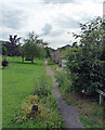
Nickey Line now a footpath
The Nickey Line is a dismantled Railway that runs from Redbourne to Hemel Hempstead. Here it runs across Keens Field.
Image: © Tom Presland
Taken: 11 Jul 2011
0.05 miles
3
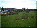
Keen Fields, Hemel Hempstead
The railway line ("Nicky Line") that used to run between the line of trees and the houses in the distance, has been turned into a cycle track. http://www.hemelhempsteadtoday.co.uk/mk4custompages/CustomPage.aspx?PageID=4092
Image: © Ray Stanton
Taken: 1 Apr 2006
0.16 miles
4
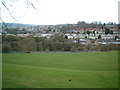
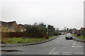
Keen Fields, Hemel Hempstead
Taken from same place on Adeyfield Road as Geograph for TL0607 but looking north rather than north east.
Image: © Ray Stanton
Taken: 1 Apr 2006
0.16 miles
6
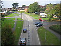
Hemel Hempstead: B487 Queensway
Viewed from the Nicky Line railway bridge, with St Pauls Road to the left and Cattsdell to the right.
Image: © Nigel Cox
Taken: 14 Oct 2007
0.21 miles
7
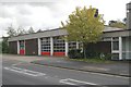
Hemel Hempstead fire station
Hemel Hempstead fire station, Queensway, Hemel Hempstead, Hertfordshire
Image: © Kevin Hale
Taken: 13 Nov 2006
0.22 miles
8
Former Practical Driving Test Centre, Hemel Hempstead
Situated in Queensway (B487), this DTC opened on Thursday 18th August 2016 replacing the former DTC at Halfords in London Road, http://www.geograph.org.uk/photo/5050320. It is adjacent to the fire station and its postcode is HP2 5HA. Update: this DTC closed on Thursday 31st October 2019.
Image: © David Hillas
Taken: 4 Oct 2018
0.23 miles
9
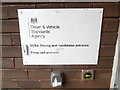
Notice at Entrance to former Driving Test Centre, Hemel Hempstead
This notice is beside the entrance to the DTC in Queensway HP2 5HA. It says the following:
DVSA Driving test candidates entrance.
Press bell and wait.
Update: this DTC closed on Thursday 31st October 2019.
The bell itself is to the left of the notice.
Image: © David Hillas
Taken: 4 Oct 2018
0.23 miles
10
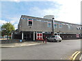
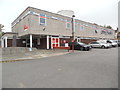
Hemel Hempstead Fire Station, Queensway
Image: © Bryn Holmes
Taken: 6 Sep 2015
0.24 miles