IMAGES TAKEN NEAR TO
Little Twye Road, TRING, HP23 6PB
Introduction
This page details the photographs taken nearby to Little Twye Road, HP23 6PB by members of the Geograph project.
The Geograph project started in 2005 with the aim of publishing, organising and preserving representative images for every square kilometre of Great Britain, Ireland and the Isle of Man.

There are currently over 7.5m images from over14,400 individuals and you can help contribute to the project by visiting https://www.geograph.org.uk
Image Map
Images are licensed for reuse under creativecommons.org/licenses/by-sa/2.0
Notes
- Clicking on the map will re-center to the selected point.
- The higher the marker number, the further away the image location is from the centre of the postcode.
Image Listing (14 Images Found)
Images are licensed for reuse under creativecommons.org/licenses/by-sa/2.0
Image
Details
Distance
1
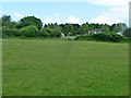
Chiltern Way
Chiltern Way heading to the drive to Bucklandwood Farm
Image: © Shaun Ferguson
Taken: 14 Jun 2009
0.05 miles
2
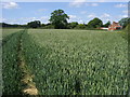
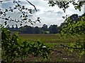
Little Twye Road from Drayton Wood
Taken from next to Image] looking southwards across fields, the parallel hedges that demarcate Little Twye Road are the most obvious feature. Little Twye Road is a minor, no-through-road that leads roughly northwards from Buckland Common serving Beechwood Farm and the few houses that are along its length.
Image: © Rob Farrow
Taken: 11 Mar 2012
0.12 miles
3
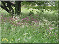
Buckland Common, Village Green
Wild flowers at their peak around the base of the crab apple tree on the Village Green, Buckland Common, May 2007
Image: © Linda Wordsworth
Taken: 11 May 2007
0.20 miles
4
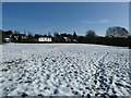
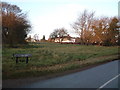
Snow covered common, Buckland Common
Presumably this grass area, seen here covered in snow, is the common which gives Buckland Common the second part of its name. Taken from the junction of a service track to houses from its junction with Little Twye Road.
Image: © Rob Farrow
Taken: 26 Jan 2013
0.20 miles
5
Footpath used by the Chiltern Way
Crossing a pleasantly grassy field near Buckland Common.
Image: © Robin Webster
Taken: 5 Jun 2014
0.20 miles
6
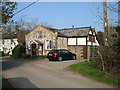
The Chapel House, Buckland Common
This building on Parrott's Lane was indeed once a chapel - but no more!
Image: © David Purchase
Taken: 9 Apr 2015
0.22 miles
7
Beechwood farm and fields from Drayton Wood
A view southwestwards out of Drayton Wood looking towards Beechwood Farm with the hedgerow delineating Little Twye Road in the distance.
Cf Image] taken eighteen months earlier from a similar position.
Image: © Rob Farrow
Taken: 29 Sep 2013
0.22 miles
8
A Common off Parrott's Lane, Buckland Common
There are several green areas around Buckland Common - whether any particular one is the eponymous "Common" I don't know.
Image: © Rob Farrow
Taken: 10 Dec 2005
0.22 miles
9
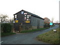
Barn with old signs, Buckland Common
There are a number of interesting old enamelled signs on this barn on Little Twye Road in Buckland Common. It is almost bisected by the 920 grid line.
Image: © Rob Farrow
Taken: 10 Dec 2005
0.22 miles
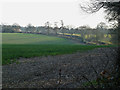
10
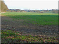
View across fields towards Buckland Common
Taken from next to Image] looking southeastwards over arable fields in the direction of Buckland Common. The edge of Drayton Wood can be seen on the left.
Image: © Rob Farrow
Taken: 11 Mar 2012
0.23 miles