IMAGES TAKEN NEAR TO
St. Leonards, TRING, HP23 6NP
Introduction
This page details the photographs taken nearby to HP23 6NP by members of the Geograph project.
The Geograph project started in 2005 with the aim of publishing, organising and preserving representative images for every square kilometre of Great Britain, Ireland and the Isle of Man.

There are currently over 7.5m images from over14,400 individuals and you can help contribute to the project by visiting https://www.geograph.org.uk
Image Map
Images are licensed for reuse under creativecommons.org/licenses/by-sa/2.0
Notes
- Clicking on the map will re-center to the selected point.
- The higher the marker number, the further away the image location is from the centre of the postcode.
Image Listing (33 Images Found)
Images are licensed for reuse under creativecommons.org/licenses/by-sa/2.0
Image
Details
Distance
1
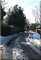
Lane to The Lee, St Leonards
This lane leads off from the main lane through St Leonards beside its eponymous church. The lane eventually leads by a spectacularly indirect route to The Lee, though you have several options to branch off before you get there to go to The Hale, or along Arrewig Lane to Chartridge, or to ignore The Lee at the last moment and go Kingsash and Wendover. Choices, choices !
Image: © Rob Farrow
Taken: 26 Jan 2013
0.02 miles
2
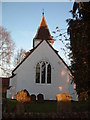
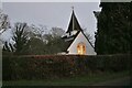
St, Leonard's Church from West
The evening sunlight illuminates the tops of the gravestones.
Image: © Rob Farrow
Taken: 10 Dec 2005
0.02 miles
4
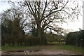
Woods by Chambers Green Road, St Leonard's
Image: © David Howard
Taken: 27 Jan 2019
0.04 miles
6
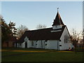
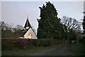
St. Leonard's Church
This very neat little church is almost on the 910 grid line, but according to the map it is just inside square SP9007
Image: © Rob Farrow
Taken: 10 Dec 2005
0.06 miles
8
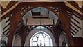
Belfry timbers
These four piers carry the belfry above.
Image: © Chris Brown
Taken: 6 Jun 2017
0.06 miles
9
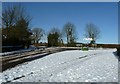
Road junction, St Leonards
This is the road junction where the lane from The Lee hits the main road (still only a country lane though) through St Leonards. Image] is just off to the right of the photographer.
Image: © Rob Farrow
Taken: 26 Jan 2013
0.06 miles
10
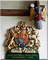
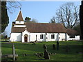
St Leonards - Church - Arms & Angel
The Royal Arms of Queen Elizabeth II on the southern wall of the nave of the church of St Leonard in the eponymous village. The arms were installed in 1963 in commemoration of churchwardens Teresa Matthews and George Small.
Above and to the right of the arms is one of eight little angels holding plain red shields that act as corbels (not necessarily structurally).
Church EH Grade II* listed: https://historicengland.org.uk/listing/the-list/list-entry/1162947?section=official-list-entry
Image: © Rob Farrow
Taken: 28 Apr 2024
0.06 miles