IMAGES TAKEN NEAR TO
Browns Lane, TRING, HP23 6LX
Introduction
This page details the photographs taken nearby to Browns Lane, HP23 6LX by members of the Geograph project.
The Geograph project started in 2005 with the aim of publishing, organising and preserving representative images for every square kilometre of Great Britain, Ireland and the Isle of Man.

There are currently over 7.5m images from over14,400 individuals and you can help contribute to the project by visiting https://www.geograph.org.uk
Image Map
Images are licensed for reuse under creativecommons.org/licenses/by-sa/2.0
Notes
- Clicking on the map will re-center to the selected point.
- The higher the marker number, the further away the image location is from the centre of the postcode.
Image Listing (19 Images Found)
Images are licensed for reuse under creativecommons.org/licenses/by-sa/2.0
Image
Details
Distance
1
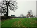
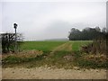
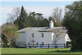
View from the Chiltern Way looking towards Hastoe
The Chiltern Way footpath (which follows the line of Grimms Ditch) is ploughed out at this point. The field is sown with winter wheat (?) which is just sprouting at the beginning of March. The hedgerow marks the line of an old bridleway, and a modern house on the edge of Hastoe can be seen in the distance.
Image: © Chris Reynolds
Taken: 1 Mar 2009
0.02 miles
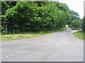
2
Browns Lane, Hastoe
Track leading off the Ridgeway in the community of Hastoe.
Image: © Chris Heaton
Taken: 30 Sep 2007
0.11 miles
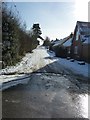
3
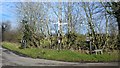
Church Lane
The Ridgeway heads down Church Lane
Image: © Shaun Ferguson
Taken: 14 Jun 2009
0.13 miles
4
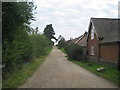
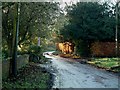
Browns Lane, Hastoe - winter
Browns Lane is a track that leads to a few houses in the hamlet of Hastoe. The lane can be legally driven through to Kiln Road near Cholesbury during the summer months if you are brave (or foolhardy) enough to take your car along this woodland track ! In the winter cars are banned, unless accessing the houses here.
See other photos of Browns Lane, mostly taken nearer its other end, in the shared description below.
Image: © Rob Farrow
Taken: 26 Jan 2013
0.13 miles
5
Hastoe hamlet
Looking down Gadmore Lane in Hastoe. A little further along this lane is the entrance to Pavis Wood, which at 244m elevation, is the highest point in Hertfordshire.
Image: © Rob Farrow
Taken: 10 Dec 2005
0.16 miles
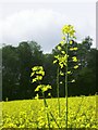
8
The Chiltern Way crosses a field
The Chiltern Way is a circular route which runs through the Chiltern Hills http://en.wikipedia.org/wiki/Chiltern_Way
Image: © Chris Reynolds
Taken: 1 Mar 2009
0.18 miles
10
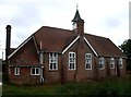
Hastoe Village Hall - rear view
There are plans for the overgrown grounds at the rear of the village hall to become a car park for the users of the hall once it has been fully refurbished.
Please look at the shared description below for more information.
Image: © Rob Farrow
Taken: 13 Aug 2011
0.19 miles