IMAGES TAKEN NEAR TO
Icknield Way, TRING, HP23 5HJ
Introduction
This page details the photographs taken nearby to Icknield Way, HP23 5HJ by members of the Geograph project.
The Geograph project started in 2005 with the aim of publishing, organising and preserving representative images for every square kilometre of Great Britain, Ireland and the Isle of Man.

There are currently over 7.5m images from over14,400 individuals and you can help contribute to the project by visiting https://www.geograph.org.uk
Image Map
Images are licensed for reuse under creativecommons.org/licenses/by-sa/2.0
Notes
- Clicking on the map will re-center to the selected point.
- The higher the marker number, the further away the image location is from the centre of the postcode.
Image Listing (53 Images Found)
Images are licensed for reuse under creativecommons.org/licenses/by-sa/2.0
Image
Details
Distance
1
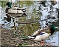
Mallard drakes, Lakeside
These mallard drakes were accompanied by several females and shared Image] with swans (see Image]) and a heron (see Image])
Image: © Rob Farrow
Taken: 19 May 2010
0.10 miles
2
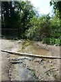
Outflow stream or drain from Tring Lake
This is the outflow stream from Image] shown on the OS map as a drain. It is heading for the brook which runs parallel with Brook Street in Tring. See also Image]
Image: © Rob Farrow
Taken: 23 Apr 2020
0.10 miles
3
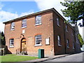
New Mill Baptist Chapel
Probably New Mill's most imposing building, situated in New Road. The inscription above the entrance reads "1689, rebuilt 1818".
Image: © David Sands
Taken: 15 Aug 2007
0.11 miles
4

Liberal Democrat Election Poster on Icknield Way, Tring
See a smaller Conservative poster Image
Image: © Chris Reynolds
Taken: 6 May 2015
0.11 miles
5
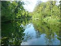
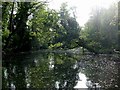
The Lake off Icknield Way, Tring
Looking WSW from the damned end of the small lake at the north of Tring. This little lake gives its name to the nearby "Lakeside" street of houses. See also Image] and Image]
Image: © Rob Farrow
Taken: 23 Apr 2020
0.11 miles
6
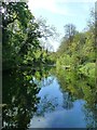
The Lake, Lakeside
This little lake - or large pond - is tucked away in trees just to the south of Icknield Way in Tring. There is a newly made path around its northern edge with wooden railings. It is a very tranquil spot with plenty of wildlife in evidence. You may be able to make out a swan swimming under the large branch. (see Image] & Image])
There were also numerous mallards (see Image]) and a Image]
This area of Tring is, not too surprisingly, called Lakeside.
Image: © Rob Farrow
Taken: 19 May 2010
0.11 miles
7
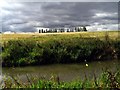
Wendover Arm at Tring Wharf
Completed in 1797, the Wendover Arm links the Grand Union Canal at Bulborne to Wendover. Due to persistent and severe leakage, the Arm was closed to navigation beyond Little Tring in 1897. The aim of the Wendover Arm Trust is to restore the Arm to full navigation, and to that end they have re-opened a short section beyond Little Tring; another isolated section adjacent to the A41 has also been restored.
This photograph was taken from the towpath of the flooded section of the Canal at Tring Wharf. The view, grabbed during a fleeting burst of sunshine, is towards Icknield Way, just below the skyline (rumour has it that this meadow is to built on).
Image: © Gerald Massey
Taken: 13 Sep 2009
0.12 miles
8
Tring Lake reflections
Taken from the same position as Image] but in portrait mode, showing the fine reflections on this lovely sunny April day.
See also Image]
Image: © Rob Farrow
Taken: 23 Apr 2020
0.12 miles
9
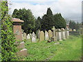
In the Graveyard of New Mill Baptist Church, Tring
The nearest stone (pink granite) relates to the Mead Family of Tring Wharf (on the Wendover Arm of the Grand Union Canal) and the Flour Mill at New Mill.
The Three Pillars relate to the Grace Family.
Image: © Chris Reynolds
Taken: 10 May 2012
0.14 miles
10
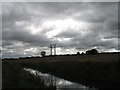
Wendover Arm at Tring Wharf
Completed in 1797, the Wendover Arm links the Grand Union Canal at Bulborne to Wendover. Due to persistent and severe leakage, the Arm was closed to navigation beyond Little Tring in 1897. The aim of the Wendover Arm Trust is to restore the Arm to full navigation, and to that end they have re-opened a short section beyond Little Tring; another isolated section adjacent to the A41 has also been restored.
This photograph was taken from the towpath of the flooded section of the Canal at Tring Wharf. I was truck by the stark outline of the electricity distribution pole and cables (which are a blight on the landscape!) against the brooding sky.
Image: © Gerald Massey
Taken: 13 Sep 2009
0.14 miles