IMAGES TAKEN NEAR TO
Little Tring, TRING, HP23 4NR
Introduction
This page details the photographs taken nearby to HP23 4NR by members of the Geograph project.
The Geograph project started in 2005 with the aim of publishing, organising and preserving representative images for every square kilometre of Great Britain, Ireland and the Isle of Man.

There are currently over 7.5m images from over14,400 individuals and you can help contribute to the project by visiting https://www.geograph.org.uk
Image Map
Images are licensed for reuse under creativecommons.org/licenses/by-sa/2.0
Notes
- Clicking on the map will re-center to the selected point.
- The higher the marker number, the further away the image location is from the centre of the postcode.
Image Listing (54 Images Found)
Images are licensed for reuse under creativecommons.org/licenses/by-sa/2.0
Image
Details
Distance
1
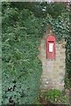
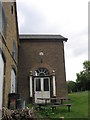
Edwardian post box in Little Tring
A little post box labelled as for "letters only" set into a wall in Little Tring. It dates from the reign of King Edward VII (1901-1910)
Image: © Rob Farrow
Taken: 1 Jan 2016
0.01 miles
2
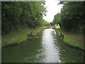
Grand Union Canal (Wendover Arm): Little Tring Stop Lock
The main cause of the closure of the Wendover Arm in 1904 was the excessive leakage of water through the banks, with the consequence that water was being drained out of the Tring summit level of the main Grand Union Canal. This stop lock was built at the time that the arm was closed to isolate the leaky section of the arm from the rest of the canal, with a view to reopening the canal should finances allow. That never happened, but the arm has now been made navigable by the Wendover Arm Trust for some 400 metres beyond the lock up to Image where it has been formally blocked. The stop lock is therefore now permanently open. As can be seen, and unlike usual locks, this one never served to change the water level.
Image: © Nigel Cox
Taken: 12 Sep 2013
0.04 miles
3
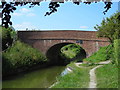
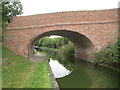
Wendover Arm Bridge No.3
This bridge at Little Tring was officially opened on May 27th, 2001, marking a major landmark in the restoration of the Wendover Arm. It's built to the design of the original 1797 bridge, which was demolished in 1973, to create a road embankment across the disused canal, effectively cutting the Wendover Arm in two.
The bridge is also said to be haunted by the ghost of a postman, or at least his lamp. The postman was last seen as he was approaching the bridge but he never got across it. He was never seen again and his bike and mail bag were never found. All that is now seen occasionally is his lamp approaching the bridge.
Image: © Mark Percy
Taken: 7 Jul 2013
0.04 miles
4
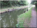
Stop lock, Wendover Arm, Grand Union Canal
A stop lock is like a pound lock in having two sets of lock gates, but if open the canal is at the same level both sides. Until 2004 the lock gates were closed and the section beyond this point was dry. There are towpaths both sides of the canal, but cycling would have been easier on the side away from the photographer.
Image: © David Hawgood
Taken: 3 Sep 2014
0.04 miles
5
Tringford Pumping Station, Wendover Arm, Grand Union Canal
The Tringford Pumping station opened in 1818, its purpose (together with other pumping stations) being to maintain the water-level in the Grand Union Canal at its summit in the Chiltern Hills.
Water was channelled through underground tunnels to wells situated directly beneath the pumping station, from where a large steam-powered Boulton & Watt beam pump raised it into the Wendover Arm of the Grand Union Canal (currently, up to 4 million gallons daily are pumped). The water then flowed by gravity to the Tring Summit section of the Grand Union Canal at Bulborne Junction. The original beam pump remained in operation for over a century before it was replaced by modern equipment, the pumping station (sadly) being altered including demolition of its chimney. Today it looks very shabby.
Image: © Gerald Massey
Taken: 13 Sep 2009
0.05 miles
6
Grand Union Canal (Wendover Arm): Bridge Number 3
Bridge Number 3 takes Little Tring Road over the canal and is a new bridge based on the design of the original from the 1790s. Please see Gerald's Image for a comprehensive description and history.
Image: © Nigel Cox
Taken: 12 Sep 2013
0.05 miles
7
Bridge 3, Grand Union Canal, Welford Arm
A bridge built to replace the bridge demolished in 1973. It was opened in 2001.
Image: © Robin Webster
Taken: 25 May 2014
0.05 miles
8
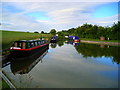
End of the Arm
The eastern section of the Wendover Arm comes to an abrupt end at this basin, marking the limit of restoration work carried out in 2004.
Image: © Mark Percy
Taken: 29 Jun 2013
0.07 miles
9
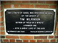
Wendover Arm plaque
This plaque erected by the Wendover Arm Trust and Inland Waterways Association marks the limit of the 2004 restoration project.
Image: © Mark Percy
Taken: 29 Jun 2013
0.07 miles
10
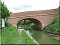
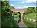
Wendover Arm: Bridge No. 3 at Little Tring
Completion in 1797, the Wendover Arm links the Grand Union Canal at Bulborne to Wendover. Due to persistent and severe leakage, the Arm was closed to navigation beyond Little Tring in 1897. The aim of the Wendover Arm Trust is to restore the Arm to full navigation, and to that end they have re-opened a short section beyond Little Tring; another isolated section adjacent to the A41 has also been restored.
But the first phase of re-opening involved bridge-building. Little Tring Road crossed the course of the canal on an embankment that blocked the canal when its original bridge was demolished in 1973. The embankment was replaced by a new bridge - No. 3, shown here - built to a traditional design and faced with bricks to give it an authentic appearance. The project was funded by the Wendover Arm Trust and completed by British Waterways in 2000/1 at a cost of £223,055.
Image: © Gerald Massey
Taken: 3 May 2009
0.07 miles