IMAGES TAKEN NEAR TO
Okeley Lane, TRING, HP23 4HD
Introduction
This page details the photographs taken nearby to Okeley Lane, HP23 4HD by members of the Geograph project.
The Geograph project started in 2005 with the aim of publishing, organising and preserving representative images for every square kilometre of Great Britain, Ireland and the Isle of Man.

There are currently over 7.5m images from over14,400 individuals and you can help contribute to the project by visiting https://www.geograph.org.uk
Image Map (Loading...)


Getting Data...Please wait
Leaflet Map data © OpenStreetMap
Images are licensed for reuse under creativecommons.org/licenses/by-sa/2.0
Notes
- Clicking on the map will re-center to the selected point.
- The higher the marker number, the further away the image location is from the centre of the postcode.
Image Listing (47 Images Found)
Images are licensed for reuse under creativecommons.org/licenses/by-sa/2.0
Image
Details
Distance
1
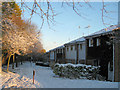
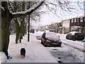
The Oakley Lane, Tring, footpath in the snow
Off the footpath to the right is access to the road.
Image: © Chris Reynolds
Taken: 19 Dec 2009
0.04 miles
2
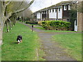
Oakley Lane, Tring
These houses front onto the footpath that runs from near the centre of Tring to Drayton Beachamp.
Image: © Chris Reynolds
Taken: 10 Mar 2009
0.04 miles
3
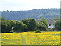
Footpath defined by buttercups
Footpath near Icknield Way, Tring.
Image: © David Sands
Taken: 26 May 2015
0.05 miles
4
Oakley Lane, Tring
These houses front onto the footpath that runs from near the centre of Tring to Drayton Beachamp.
Image: © Chris Reynolds
Taken: 10 Mar 2009
0.06 miles
5
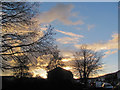
Sunset across the grass square in Buckingham Road, Tring
The trees silhouetted against the sky were planted in the grass square about 45 years ago, not long after the estate was built.
Image: © Chris Reynolds
Taken: 19 Nov 2018
0.06 miles
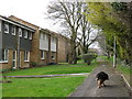
6
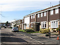
Buckingham Road, Tring
The west end of the road consists of terraced houses and were built by a different builder two or three years later that the houses at the east end of the road.
Image: © Chris Reynolds
Taken: 6 Mar 2009
0.06 miles
7
The Trees on the Green and the snow in Buckingham Road, Tring
Some of the parked cars have left for work, leaving almost bare patches where they were parked. The road has not yet been salted but cars have left tyre marks and perhaps brought some salt in on the treads from Miswell Lane.
The trees on the left are between the Green left as a play area between the two parts of the estate, and were planted in about 1970. Unfortunately the two nearest trees died from vandalism. They were probably already dying when this picture was taken.
Image: © Chris Reynolds
Taken: 23 Dec 2009
0.07 miles
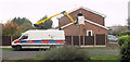
8

The demeaning last journey from Buckingham Road, Tring
The ceremonial way in which this car is being hoisted on board a lorry carrying the name "Metal Recycling" suggest that the car has well and truly come to the end of the road.
Image: © Chris Reynolds
Taken: 4 Jan 2016
0.09 miles
9
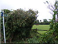
Footpath from Icknield Way to Okeley Lane Tring
Image: © David Sands
Taken: 29 Sep 2007
0.09 miles
10
Replacing a Street Light Bulb in Buckingham Road, Tring
A very routine operation for the person doing it, but one well worth recording for posterity. When I was writing the First World War book "The London Gunners come to Town" I was very interested in how Hemel Hempstead Borough Council kept the town running - and I was unable to find a single 100 year old photograph showing a Council workman at work.
Most of the lamp posts in the road have been replaced with metal ones in recent years, but this post is one of the original concrete lampposts.
Image: © Chris Reynolds
Taken: 3 Nov 2015
0.10 miles