IMAGES TAKEN NEAR TO
Halton Wood Road, AYLESBURY, HP22 5QH
Introduction
This page details the photographs taken nearby to Halton Wood Road, HP22 5QH by members of the Geograph project.
The Geograph project started in 2005 with the aim of publishing, organising and preserving representative images for every square kilometre of Great Britain, Ireland and the Isle of Man.

There are currently over 7.5m images from over14,400 individuals and you can help contribute to the project by visiting https://www.geograph.org.uk
Image Map
Images are licensed for reuse under creativecommons.org/licenses/by-sa/2.0
Notes
- Clicking on the map will re-center to the selected point.
- The higher the marker number, the further away the image location is from the centre of the postcode.
Image Listing (19 Images Found)
Images are licensed for reuse under creativecommons.org/licenses/by-sa/2.0
Image
Details
Distance
1
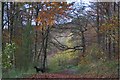
Wendover woods in Autumn
Dog walking in Wendover woods with the autumn colours around
Image: © Robert Firth
Taken: 10 Nov 2006
0.16 miles
2
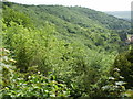
Glimpse of Boddington Hill from Haddington Hill
Green is the colour - Wendover Woods in summer.
Image: © Peter S
Taken: 2 Jun 2012
0.17 miles
3
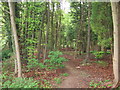
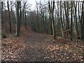
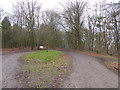
Footpath into the woods, Halton
This is an unmarked path into the woods to the East of the footpath marked on the map at this point (which is just off to the left of this photograph). This little wood does not appear on the 1940s map suggesting that it is comparatively recent. The land to West of this point is taken up by RAF Halton and associated accommodation (both accommodation blocks and houses), however before its military use the land was probably owned by the Rothschilds as the Officers' Mess for example is an old Rothschild Mansion.
There is quite a substantial amount of development going on around here, and some of the former military-owned houses are up for sale to the general public.
Image: © Rob Farrow
Taken: 14 May 2006
0.17 miles
4
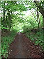
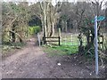
Track through the woods, Halton
This wood is adjacent to Halton RAF base which dominates the adjacent gridsquare. There are several paths through this woodland which is considerably lower down than Halton Wood which is part of Wendover Woods, the Forestry Commission land above the village.
Image: © Rob Farrow
Taken: 14 May 2006
0.17 miles
5
Path to Beechwood Lane
Path heading down to Beechwood Lane
Image: © Shaun Ferguson
Taken: 18 Jan 2019
0.18 miles
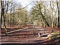
6
Start of the Fitness Trail
Following the outline of the old hill fort on Boddington Hill, the Fitness Trail is a pleasant woodland path with unobtrusive wooden exercise features at intervals should you feel so inclined.
Image: © Des Blenkinsopp
Taken: 12 Jul 2022
0.18 miles
7
Path heading into Wendover Woods
From Beechwood Lane bridleway the path heading into Wendover Woods
Image: © Shaun Ferguson
Taken: 18 Jan 2019
0.19 miles
8
Woodland Track on Boddington Hill
The trees on the left mark the easterly end of the Iron Age Camp known as Boddington Banks, while the track runs along the line of the old ditch.
Image: © Chris Reynolds
Taken: 2 Mar 2009
0.19 miles
9
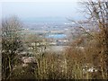
A gap in the trees reveals Weston Turville Reservoir
There are several large open picnic areas adjacent to the track from the café to Boddington Banks. Nearly everywhere the bordering trees hide the views. The small gap at this point allows one to see Weston Turville Reservoir – but the trees are growing and, unless action is taken, it will be invisible in a few years time.
(Western Turville Reservoir was constructed in 1795 to supply water to what was then the Grand Junction Canal via the Wendover Arm.)
Image: © Chris Reynolds
Taken: 2 Mar 2009
0.19 miles
10
Approach to the hillfort in Wendover Woods
The hillfort lies ahead.
Image: © Jeremy Bolwell
Taken: 13 Jan 2018
0.19 miles